

IONS TACTICAL PUBLICATION (ITP)
Originator: I.R. Iran Navy — April 2019 — Version 1.0 — UNCLASSIFIED
Publication Notice Routing
- IONS Tactical Publication (ITP) is available and it is effective upon receipt.
- ITP is designed for use by IONS members when conducting exercises or operations with naval units. It provides naval manoeuvring concepts and signalling instructions for units of different navies that have not historically operated together and do not have agreed-on procedures. ITP only supports basic tactical exercises and operations. It is not intended to support sophisticated or warfare-specific coordinated operations.
- ITP is UNCLASSIFIED and does not require security protection.
I.R. Iran Navy
Tehran — Iran
Letter of Promulgation
- ITP, IONS Tactical Publication, is one of a series of publications designed for use in operations between IONS naval forces at sea. It is a stand-alone document and shall be maintained separately from other nation’s tactical book.
- ITP is effective upon receipt.
- ITP is UNCLASSIFIED and requires no security protection. It may be released to non-IONS member nations independently by member nations.
- International code of signal (Flags or Morse code or Emerg. voice procedure and ...) will remain in force.
- Terms and Procedures used in this document are similar with TERMS uses in most Naval Forces.
Rear Admiral, I.R. Iran Navy
Introduction
Since the establishment of IONS, there has been a need for a common language and understanding in maritime operations, and has been emphasized in the CoCs and IWG meetings, including the IS&I, HADR, and MARSEC.
After taking the responsibility of the chairmanship of IONS by the I.R. Iran Navy in May 2018, this request was taken into consideration by the Tehran-based secretariat of the symposium, and due to the emphasis of the commander of the I.R. Iran Navy to adopt practical approaches with greater convergence, an order was made to develop a tactical publication for IONS called ITP.
To this end, a team of experts from the I.R. Iran Navy was formed in order to develop and compile the present publication in accordance with the principles of combined operations and the use of existing international tactical publications, so that all combined operations and HADR operations required by IONS can be covered. Thus, in order to conduct different kinds of required operations, IONS wouldn’t need to refer to various tactical publications and international coding, other than the International Code of Signal.
Undoubtedly, the present publication is at the first phase and to complete it, it needs the guidance and technical assistance of other maritime experts of the member countries and in this regard, I.R. Iran Navy with regarding to the opinions of other members, considers these four phases:
Phase 2: Reviewing the publications content by IONS member states and changing the codes and creating new coding, in case of need and approval of countries.
Phase 3: Its final confirmation at the CoC to be the basis of IONS maritime operations.
Phase 4: In case of need and the consent and approval of the members in the CoC, this publication can be classified and restricted and this means changing the code in a new phase and allocating the promulgation of this publication amongst the members.
I.R. Iran Navy hopes that this effort will bring greater convergence amongst members in the maritime security operations in the Indian Ocean, while at the same time addressing the need for a tactical publication; the initial steps can be taken to improve and advance to the development and growth of the member states.
ITP Record of Changes
| Identification of Change / Reg No. (if any), and Date | Date Entered | Effective Date | By Whom Entered (Signature; Rank; Grade or Rate; Name of Command) |
|---|---|---|---|
Contents
| Section | Page |
|---|---|
| PART 1 — TACTICAL MANOEUVRING | 11 |
| Chapter 1. General Instructions | 13 |
| Chapter 2. Task Organization and Command and Control | 19 |
| Chapter 3. Position, Movement, and Manoeuvring | 23 |
| Chapter 4. Disposition of Forces | 27 |
| Chapter 5. Communications | 37 |
| Chapter 6. Merchant Ship Best Management Practices to Deter Piracy | 41 |
| PART II — TACTICAL SIGNALS | 45 |
| Chapter 1. FORM (Formation) Signals | 47 |
| Chapter 2. Station Signals | 53 |
| Chapter 3. Turn Signals | 59 |
| Chapter 4. CORPEN (Course) Signals | 63 |
| Chapter 5. Speed Signals | 67 |
| Chapter 6. Screen Signals | 71 |
| Chapter 7. Special Tactical Signals | 75 |
| Chapter 8. Two-Letter Modifiers | 83 |
| Chapter 9. Emergency Signals | 87 |
| Chapter 10. Air Operation Signals | 91 |
| Chapter 11. Air Operation Action Table | 95 |
| Chapter 12. Administration Signals | 99 |
| Chapters 13–33 | 105–201 |
| PART III — Maritime Miscellaneous Operations | 205 |
| Annex A. Glossary of Terms, Acronyms, and Abbreviations | 239 |
Chapter 1 — General Instructions
01. General
1. IMMTS, in common with most military disciplines, relies heavily on communications to affect command and control, pass data and disseminate information. This may be made more complex by the wide geographical dispersal of IONS elements and the need to utilize both military and commercial communication channels.
Military and Non-Military Communications
2. The aim of IMMTS is to provide channels that facilitate the passing of data and dissemination of information among military and non-military organizations. As operations expand, the detailed communications plan will become more complex.
Information Exchange Requirements
3. IONS military Information Exchange Requirements (IERs) are relatively simple in concept. These are being met by both conventional methods and increasingly technology based solutions. Conventional methods include signal messages, very high frequency (VHF) radio, fax transmissions, and secure and non-secure telephone.
4. The challenge is to establish connectivity with a number of IONS elements distributed over the geographic area often in non-military locations. This requires a flexible communications’ architecture capable of providing maximum connectivity while preserving communications’ security. The overall communications requirements will be determined through consultation with the Maritime component communications staff officer and will be driven by the scope and scale of the operation.
02. Frequency (communication layers)
5. Due to the international rules, the use of shared frequencies in different territorial and marine areas requires special coordination and, ultimately, coordination with the ITU organization.
(1) VHF-HB Marine Band (Frequency Range 136-174 MHz)
• Initial communication on international
channel 16 (156. 800)
• By coordinating the stations of the operator, channels (one to 28) or
(60 to 86) are communicated (equal to the following frequency table)
(1) Tactical UHF Band
(Frequency Range 220-320 MHz)
• Basic communication on the international guard frequency (243
MHz)
• Communicates with the coordinator of the stations on the agreed frequency
(2) VHF-AB band for air control (frequency range 108-136 MHz)
• Initial communication on the
frequency of the international guard (121.5 MHz)
• Communicates with the coordinator of the
stations on the agreed frequency
(3) HF band Long range (frequency range 1. 6-30 MHz) • Initial communication on the frequency of the
international guard (21850 kHz)
• Communicates with the coordinator of the stations on the
agreed frequency (4) Emergency satellite systems of the GMDSS system
• Depending on the location
of the operator station, the satellite type is selected for communication Military units are not
required to connect to satellites
Radio call sign (c/s)
6. In order to determine the radio reagent(c/s) in normal time and at the time of the exercise (crisis), specialized coordination meetings are required with the member states.
The Radio Reagent radio is a Latin word for each work station and a Latin word for telephoning.
Common phrases (code table and discovery)
7. To determine the pumpkin's table, the discovery of commonly used phrases in normal time and at the time of the exercise requires a special coordination with the member states.
Communication codes include common phrases in various maritime areas (maritime security, relief, emergency, etc.) that are encoded in combination of Latin letters and numbers.
Address Tables
8. Exchange is a security measure that protects a communication system against tampering. The table is a table 8 * 8 that is made up to the number of days of the week (seven days). The first row and the first column are composed of three digits, and the rest of the table is composed of Latin words. The requesting station addresses a three-digit number from the key column and a three-digit of the key row, and the station receives the cross between the column and the row of the sent key (the word) to the front of the station.
03. IONS Tactical Publication (ITP)
9. ITP is designed for use by IONS element when conducting exercises or operations with the navies. It provides naval maneuvering concepts and signaling instructions for units of different navies that have not historically operated together and do not have agreed-on procedures. ITP only supports basic tactical exercises and operations. It is not intended to support sophisticated or warfare-specific coordinated operations.
Chapter 2 — Task Organization & Command and Control
01. Task Organisation
1. Whenever two or more ships are operating together a task organization is needed to delineate responsibility and establish a well-defined tactical chain of command. Each task organization will consist of a task group (TG). TGs may be subdivided into smaller, subordinate task units (TUs). TUs, in turn, may be divided into smaller, subordinate task elements (TEs). TUs and TEs are normally formed for specific purposes or to meet specific missions (e.g., communication exercises, search and rescue, etc.
2. Task Group (TG). During all exercises and operations participants will be organized into a TG. The tasking message establishing the exercise or operation will assign a number to the TG (e.g., TG 18.1) and a TG commander (CTG).
3. Task Unit (TU). Each TG may include two or more smaller, subordinate TUs. The tasking message establishing the exercise or operation will assign units to TUs, TU numbers (e.g., TG 18.1.1), and TU commanders (CTUs).
Task Element (TE). Each TG with TUs may also contain smaller, subordinate TEs. The tasking message establishing the exercise or operation will assign units to TEs, TE numbers (e.g., TE 12.1.1.1), and TE commanders (CTEs).
02. Tactical Command (TACOM)
4. TACOM is the authority to assign ships to specific tasks within an exercise or operation. It involves issuing detailed orders and ensuring their correct execution. It also involves responsibility for the general safety of assigned units, although ultimate responsibility for safety remains with the commanding officer of each unit. TACOM does not include the authority to assign tasks inconsistent with the exercise or operation. TACOM is assigned to the CTG of a specific exercise or operation.
0203. Tactical Control (TACON)
5. TACON is the authority to direct and control the movements or manoeuvres of ships to accomplish the exercise or operation. TACON is assigned to the CTG and may be delegated to subordinate CTUs or CTEs.
Chapter 3 — Position, Movement, and Manoeuvring
01. Latitude and Longitude
1. Position may be expressed in degrees of latitude and longitude. When expressing position by latitude and longitude, latitude will be stated first and will include an N for North or an S for South. Longitude will follow latitude and will include an E for East or a W for West.
02. Bearing and Distance
2. Position may be expressed as a bearing and distance (sometimes referred to as range) from a reference position (RP), whose location is known to all participants. This RP may be a fixed geographic location, a specific TG ship (such as the Guide), or any other point promulgated to or known by all TG ships. The order of reporting position by bearing and distance will be: bearing in degrees true (° T) from the RP, identification of the RP, and distance from the RP in nautical miles (nm) or yards (yd)
03. Designated Stations
3. Position may be expressed by reference to a designated station. A designated station is an area or point that has been established either in the tasking message or by communication during the exercise or operation. A designated station will normally be defined by either latitude or longitude or bearing and distance from an RP, and may be either stationary or moving.
04. Arrival and Departure
4. When a port visit is scheduled during or immediately before or after an exercise or operation, ships will request berths and proceed to and from port under national guidelines. The tasking message should establish the location and time ships revert to national control prior to entering port and/or the time ships join the TG upon departing port.
Chapter 4 — Disposition of Forces
01. Basic Formations
1. Line Formations. There are several basic line formations:
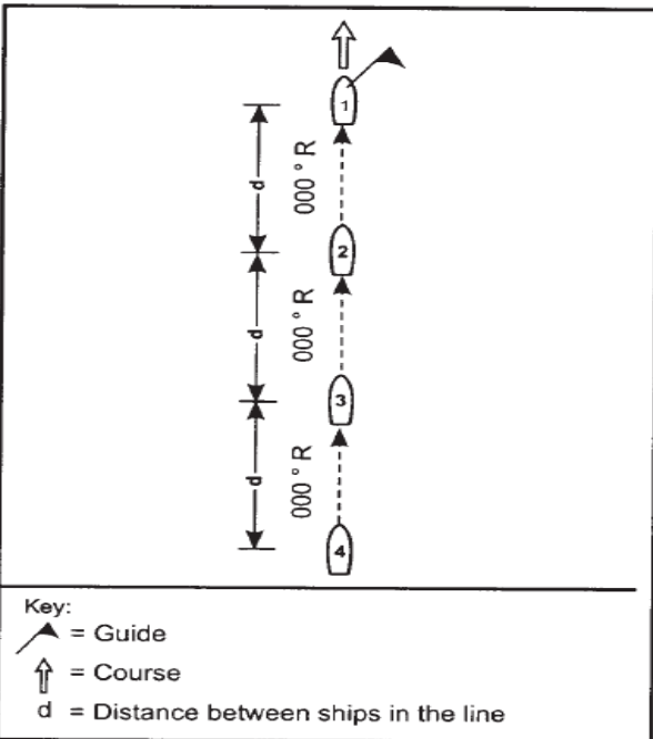
1.1. Column. In a column formation ships are formed in a line, bow-tostern, with station 1 the lead ship in the line. Subsequent stations in the line are directly astern station 1 and are numbered sequentially (stations 2, 3, 4, etc.). The bearing between stations in the line is the same as the course of the column formation. The distance (d) between stations is the standard distance (D) promulgated in the tasking message. The Guide can be assigned to any station. Figure 1 shows a typical column formation.
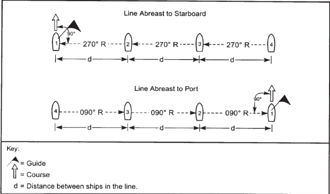
1.2. Line Abreast. In a line abreast formation ships are formed in a line, beam to beam, with station 1 at one end of the line. If subsequent stations (stations 2, 3, 4, etc.,) are to starboard of station 1 the formation is a line abreast to starboard. If subsequent stations are to port of station 1 the formation is a line abreast to port. The bearing between stations in the line is perpendicular to the course of the line abreast formation. The distance (d) between stations is the standard distance (D) unless specified otherwise. The Guide can be assigned to any station. Figure 2 shows the two possible line abreast formations: line abreast to starboard and line abreast to port.
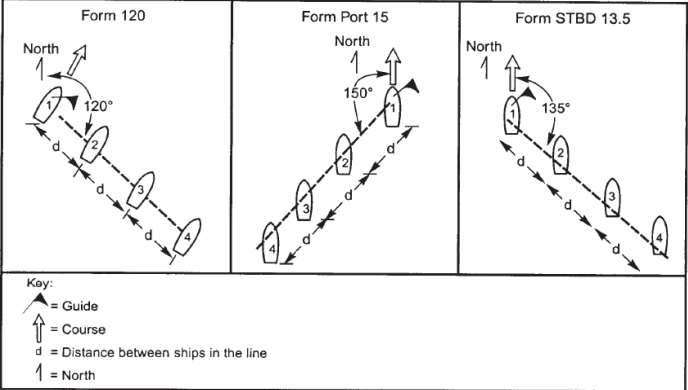
1.3. Line of Bearing. In a line of bearing formation ships are formed in a line with station 1 at one end of the line. Subsequent stations (stations 2, 3, 4, etc.) are aligned along the designated line of bearing. The bearing is designated either as the true bearing from station 1 using the signal FORM and the true bearing or as the relative bearing between the course of the formation and the desired line of bearing using the signal FORM followed by PORT or STARBOARD and a number of tens of degrees. The distance (d) between stations is the standard distance (D) unless specified otherwise. The Guide can be assigned to any station. Figure 3 shows sample line of bearing formations.
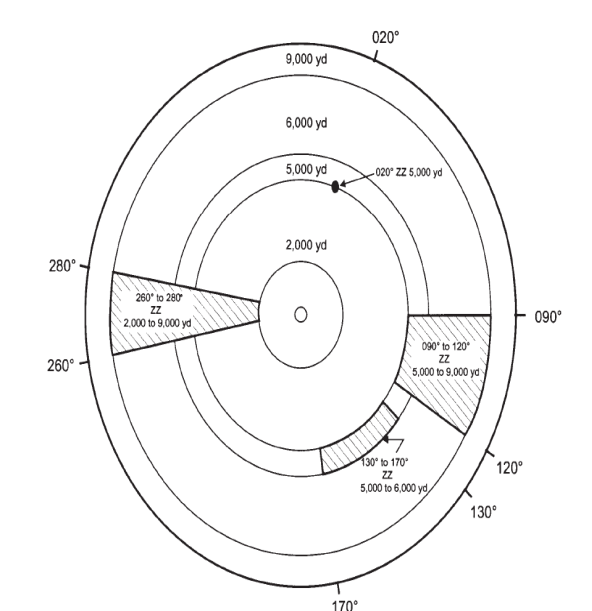
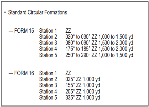
1.4. Circular Formations. In a circular formation, ships are assigned stations around the center of the formation (ZZ). Stations are designated as a specified bearing or range of bearings in degrees true (° T) from ZZ and a specified distance or range of distances from ZZ. Figure 4 shows some sample circular formation stations. The tasking message may be used to establish one or more standard circular formations for the exercise or operation. The establishment of standard circular formations reduces the need for lengthy signals during conduct of the exercise or operation.
SCREENS
2. The purpose of a screen is to protect a main body or convoy. It may be designed to provide protection against aircraft, missiles, submarines, or surface forces. In a multi threat environment, due consideration must therefore be given to the assessment of threat priorities and the advanced warning which can be obtained by the force. Since the threat can change during an operation, continuous reassessment of the situation is necessary to maintain the efficiency of the screen. Since present weapons and sensors demand defense in depth, screens should be adequately dispersed, thus increasing the enemy’s problem in recognizing and attacking the main target.
Sector Screen
3. Sectors are chosen to exploit the individual equipment capabilities of various screen units and to provide flexibility and defense in depth. Sectors are defined by true bearings and distances from screen center. Screen units patrol assigned sectors; the amount of patrolling and the size of the sector depend on the speed advantage of the screen unit over the main body or convoy. Random maneuvering in sectors has the advantage of disguising the disposition of the force and thus poses an additional recognition problem to an enemy.
3.1. Description The center is ZZ or QQ, unless otherwise ordered. Sectors are allocated by indicating sector boundaries and sector depth (separated by a tack) followed by the call sign of the unit assigned to that sector.
3.2. Sector Boundaries are ordered by a group of four numerals. First two numerals indicate the true bearing of the left boundary in tens of degrees; the second two numerals indicate the true bearing of the right boundary in tens of degrees.
3.3. Sector Depth is also ordered by a group of four numerals. First two numerals indicate the inner limit and the second two the outer limit of the sector in thousands of yards from the screen center.
02 - Altering Formation Course
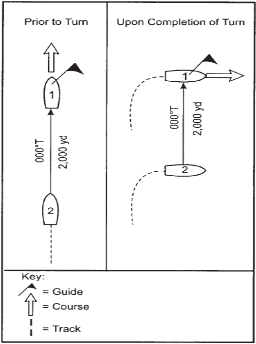
4. Turn A turn is a maneuver used by line and circular formations in which all ships alter course simultaneously and maintain true bearing to the Guide.
4.1. Figure 6 shows a two-ship column formation initially on course 000° T. Prior to a signaled turn to course 090° T, the Guide (station 1) bears 000° T and 2,000 yards from the ship in station 2. Upon completion of the turn the Guide still bears 000° T and 2,000 yards from the ship in station 2. Upon completion of the turn in this example the column formation has become a line abreast to starboard formation.
4.2. At night or in low visibility, formation turns in excess of 90° should be ordered in two or more increments, each of 90° or less. The second increment should not be ordered until all ships in the formation are steady on the course ordered by the first increment. It is also advisable to execute turns of greater than 90° in increments when the formation consists of ships of different sizes and/or turning diameters.
Corpen
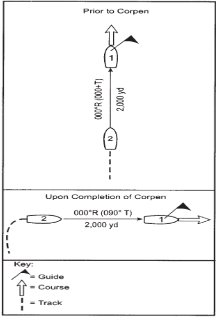
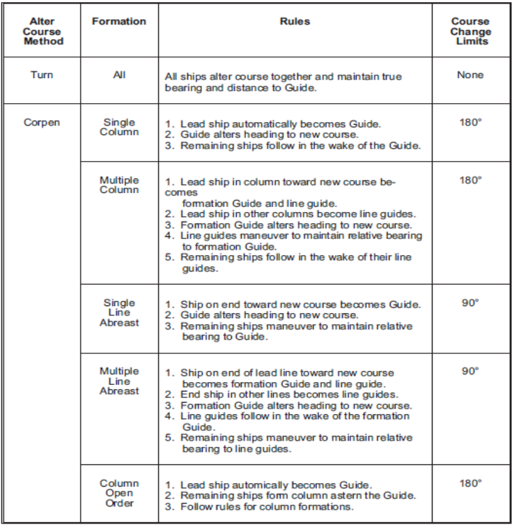
5. A corpen is a line formation maneuver in which ships alter course so that the relative bearing to the Guide is the same at the completion of the maneuver as it was at the start of the maneuver.
5.1. Circular formations do not alter course by corpen maneuvers.
5.2. Upon execution of a corpen maneuver, ships in a column open order are to form a column, follow in the wake of the Guide, and reform in a column open order when all ships in the formation have completed the corpen maneuver.
5.3. Figure 7 shows a two-ship column formation initially on course 000° T. Prior to a signaled corpen to course 090° T, the Guide (station 1) bears 000° R (000° T) and 2,000 yards from the ship in station
2. Upon completion of the corpen maneuver, the Guide bears 000° R (090° T) and 2,000 yards from the ship in station 2. Upon completion of the corpen maneuver in this example the ships remain in a column formation.
The amount of course change that should be executed by a single corpen maneuver varies with the type of formation. Recommended maximum corpen maneuvers for the various types of formation are:
(1) Column - 180°
(2) Line abreast - 90°.
(3) Line of Bearing- Corpen not used.
(4) Column Open Order - 180°.
(5) Diamond - 30°.
(6) Circular - Corpen not used.
ALTERING COURSE BY SEARCH TURN
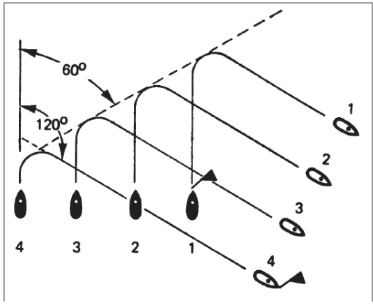
6. The search turn (Figure 8) is for use when altering course while searching an area with ships in line abreast or loose line abreast.
6.1. RESTRICTION. Ships in line abreast must be at least 1,000 yards apart; those in loose line abreast must be at least 1,500 yards apart. Ships of ocean minesweeper size and smaller may conduct search turns when the distance between ships is 500 yards. The alteration must not be less than 45° or more than 135°.
EXECUTION. The wing ship on the side away from the direction of the new course is to turn to the course indicated and become the Guide. The remaining ships are to continue their course, each one turning in sequence, so that on completion of her turn she will be on the beam of the Guide on the new course. For large alterations when in loose line abreast, the OTC should consider ordering ships to reform in line abreast before executing the search turn.
Summary Table 1 summarizes information presented:
Chapter 5 — Communications
01. Visual Communications
1. Although voice radio is the preferred method of communication, visual communications may be used on occasion. Visual communication methods that may be used include flag and flashing light communications. All visual communications will be in accordance with the International Code of Signals. Visual communications will not be used for tactical manoeuvring.
02. Radio teletype Communications
2. One or more radio teletype circuits will be assigned for each exercise or operation. Radio teletype will be used for planning and coordinating exercise or operation matters. Unless otherwise agreed, English will be used in all radio teletype communications. The exercise or operation tasking message will specify each radio teletype circuit’s name, radio frequency, backup (secondary) frequency, intended use, the command assigned control of the circuit, and participants on the circuit.
03. Voice Radio Communications
3. Voice radio will be the primary method of communication during exercises and operations covered by this manual. Circuits and call signs for voice radio communications will be promulgated in the tasking message. Each circuit assigned will specify the circuit’s name, radio frequency, intended use, the command assigned control of the circuit, and participants on the circuit. Backup, or secondary, frequencies will be assigned when feasible.
Chapter 6 — Merchant Ship Best Management Practices to Deter Piracy- (BMP)
01. Introduction
1. The guidance within this section primarily focuses on preparations that might be within the capability of the ship’s crew, or with some external assistance.
The Merchant Ship Protection Measures described are the most basic that are likely to be effective. If pirates are unable to board a ship they cannot hijack it.
02. Merchant Ship Protection Measures:
- Watch keeping and Enhanced Vigilance
- Enhanced Bridge Protection
- Control of Access to Bridge, Accommodation and Machinery Spaces
- Physical Barriers
- Water Spray and Foam Monitors
- Alarms
- Closed Circuit Television (CCTV)
- Manoeuvring Practice
- Upper Deck Lighting
- Deny Use of Ship’s Tools and Equipment
- Protection of Equipment Stored on the Upper Deck
- Safe Muster Points / Citadels
- Unarmed Private Maritime Security Contractors
- Armed Private Maritime Security Contractors
03. In the Event of Military Action
1. In the event that Naval/Military forces take action on board the ship, all personnel should keep low to the deck and cover their head with both hands, with hands visible. On no account should personnel make movements which could be misinterpreted as being aggressive.
2. Do not use flash photography.
3. Be prepared to be challenged on your identity. Brief and prepare ship’s personnel to expect this and to cooperate fully during any Naval/Military action onboard.
4. be aware that English is not the working language of all Naval/Military forces in the region.
Naval/Military forces will endeavor to respond rapidly to ongoing acts of piracy.
However because of the very large distances across the High Risk Area a Naval/Military response may not be possible.
04. Anti Piracy Checklist
- Upon discovery of suspicious craft nearby, has the Master been immediately alerted?
- Has the engine room been informed?
- Has the emergency alarm been sounded?
- Has the imminent piracy attack been announced over the P.A system?
- Have both the radars been switched on?
- Have extra lookouts been posted on the bridge?
- Has the muster point been determined in case of a imminent piracy attack?
- Has the nearest port authority/marine police been informed of the attack?
- Have all ship’s in the vicinity been alerted of the piracy attack?
- Have all crew assembled at agreed muster point?
- Has the crew been asked to stand-by, prepare defense, and barricade all access routes to?
- Ship and all w/t & fire doors of accommodation & engine room entrances locked up, leaving only one open guarded access for emergency?
- Has the updated position / information broadcasted over the radio/VHF?
- Has the search light been directed towards the craft to possibly blind the pirates?
- Have all deck lights been switched on?
- Has the crew been warned to avoid violence & only take action for selfdefense in case of attack by Pirates?
- After the pirates have gone, have checks been carried out to assess loss & damage to report to the company, charterer, coast state etc.., about the attack?
- Have records of all actions taken been maintained in the ship’s deck/ official log book?
Chapter 1 — FORM (Formation) Signals
FORM (Formation) Signals = (FORM)
01. Formation Signals
Standard Distance – 1000 Yards
Note: All formation signals contain the term FORM within the signal.
1. Column and Line Abreast
When forming a column or a line abreast, ships take station in the order of sequence numbers or as directed by the signal. The distance between ships is the standard distance (D) or the distance indicated by the signal. The Guide is designated in the signal. If the Guide is not designated, the Guide is the ship that was the Guide of the previous formation or the CTG if no previous formation existed.
FORM 1 — Form a column.
FORM 2 — Form a column in reverse order of sequence numbers.
FORM 3 — Form a line abreast to starboard.
FORM 4 — Form a line abreast to port.
FORM 5 — Form a second column to starboard of the first, line guides bearing abeam.
FORM 6 — Form a second column to port of the first, line guides bearing abeam.
FORM 9 — Form a second line abreast to starboard, line guides bearing astern.
FORM 10 — Form a second line abreast to port, line guides bearing astern.
Examples: FORM 1 — Form a column in order of sequence numbers
FORM 1.STATION 1 DESIG ABC. STATION 2 DESIG DEF.G FORM DESIGABC . . . Form a column. Ship ABC in station 1, ship DEF in station 2. Formation Guide is ship ABC.
2. Circular Formation
When forming a circular formation, ships take station in the order of sequence numbers or as indicated in the tasking message or signal.
FORM 14 — Form a circular formation with stations as indicated.
FORM (15 to 19) — Form circular formation designated in the tasking message.
Examples: Examples: FORM 14.STATION 1 DESIG ZZ.STATION 2 DESIG 030.050 ZZ 1 ANS 5 -2.. . Form circular formation with station 1 at ZZ and station 2 bearing 30°to 50° from ZZ at a distance of 1.5 to 2 nm. Ships take station in order of sequence numbers.
FORM 15.STATION 1 DESIG ABC.STATION 2 DESIG DEF . . . Form circular formation 15 designated in the tasking message. Ship ABC is assigned station1 and ship DEF is assigned station 2
3. Line of Bearing
Ships form on the Guide on the bearing signaled or its reciprocal. Ships form in the quickest sequence, in the order of sequence numbers, or as indicated. FORM (PORT or STBD) (0 to 18) . . . Form a line of bearing formation on a relative bearing in tens of degrees (0 to 18) from the Guide or ship indicated on the present course or course indicated.
FORM (000 to 359) — Form a line of bearing formation on a true bearing from the Guide or ship. indicated on the present course or course indicated.
Examples: FORM 120 . . . Form a line of bearing on a bearing of 120° T from the Guide on the present course. FORM PORT 15.STATION 1 DESIG ABC.STATION 2 DESIG DEF.G FORMDESIG ABC.B CORPEN 000 . . . Form a line of bearing formation on a relative bearing of 210° R from ship ABC, which is assigned station 1; ship DEF is assigned station 2. Formation Guide is ship ABC. Base course is 000° T.
4. Forming in the Quickest Sequence
The quickest sequence is based on each ship’s position relative to the Guide or ship indicated at the time the signal is executed. It does not mean to form in order of sequence numbers.
FORM A — Form a column formation in the quickest sequence on the most advanced ship or ship indicated, at present distance if already formed, or at standard distance or distance indicated. Unless a particular ship has been indicated, the ship to be formed on is the most advanced ship on the present course. Remaining ships are to form astern of that ship in the quickest sequence, according to their positions relative to that ship. If the ship to be formed on is indicated, ships are to form ahead or astern in the quickest sequence.
Example: FORM A — Form a column formation in the quickest sequence on the most advanced ship at the present distance.
FORM B — Form a line abreast formation in the quickest sequence on the Guide or ship indicated, on the present course or course indicated, at present distance if already formed, or at standard distance or distance indicated.
Ships are to form on the nearest beam of the Guide or ship indicated, relative to that ship’s course or the course indicated, in the quickest sequence according to their positions relative to the Guide.
Example: FORM B.G FORM DESIG ABC.B CORPEN 000.TA12.3 . . . Form a line abreast formation in the quickest sequence on ship ABC as formation Guide. Base course is 000° T. Take double standard distance (2D).
5. LOOSE LINE OF COLUMN, DIAMOND FORMATION, COLUMN OPEN ORDER, AND REVERSING THE ORDER OF SHIPS IN COLUMN
FORM C PORT/STBD — FORM LOOSE LINE OF COLUMN TO PORT OR STBD as indicated. A loose line of column can only be formed when ships are in column. The leading ship is automatically to become the Guide. Ships are to take station on the indicated quarters of the Guide on an approximate line of bearing within 15° of column. Distance may be increased to reduce yawing.
FORM D — Form a diamond formation.
6. A diamond formation can only be formed when ships are in a column formation. The leading ship automatically becomes the Guide. The second ship in the column is to form on the port quarter of the Guide, the third ship on the starboard quarter of the Guide, and the fourth ship in the wake of the Guide. If there are more than four ships, additional ships are to form a second diamond on the fourth ship, odd numbers (counting from the leading ship) forming to starboard, even numbers forming to port. Unless otherwise ordered ships are to use their present ordered distance (d).
FORM E — Form a column open order formation.
7. In forming a column open order formation, ships are displaced on both sides of the course, even numbered ships (counting from the leading ship) forming to port and odd-numbered ships to starboard.The leading ship automatically becomes the Guide. The second ship forms 4° on the port quarter of the Guide and the third ship 2° on the starboard quarter of the Guide; remaining ships form alternately astern of the second or third ship on the appropriate side.
Ships are to form at the same distance from the Guide as if they were in column. If the column is already formed, ships are to remain at their present ordered distance unless otherwise directed.
FORM F PORT or STBD — Reverse the order of ships in column in succession from the rear. Ships are to sheer out on the side indicated.
One or two numerals may be added to indicate speed of all ships except the rear ship.
The rear ship automatically becomes the Guide and increases speed to one knot less than stationing speed, passing the ships ahead of her on the side indicated. Other ships reduce speed to 7 knots or as indicated.
At the appropriate time, each ship in succession from the rear is to increase speed and take station in the wake of the ship that was previously next astern to her. All ships will maintain speed after taking station in the new column until the CTG reduces speed by a speed signal.
If the manoeuvre is ordered when ships have no way on, the new Guide’s speed will be signalled; each ship will subsequently get underway in succession from the rear in time to complete the manoeuvre.
02. Miscellaneous Signals
FORM U — Ships resume previous relative bearings and distances from their line guides. Ships move independently.
FORM V — Line guides resume previous relative bearings and distances from the Guide. Line commanders move their lines by signal to take up new stations.
FORM W — Resume previous formation. Line guides resume previous relative bearings and distances from the Guide. Ships in line resume previous bearings and distances from their line guides. Line commanders direct movements.
FORM Z — Remain in present formation (until ____ ).
Example: FORM Z.19T — Remain in present formation until 1900Z.
03. Information Signals
B FORM — Force is in formation number ____ (this unit or unit(s) indicated are in station(s) indicated).
G FORM — Formation Guide is ____ (in station ____ or bearing ____° T from this unit or unit indicated at a distance of ____ hundred yards).
Example: GFORMDESIGABC.STATION 1 — Formation Guide is ship ABC in station 1.
K FORM — Formation center bears ____° T from the Guide or ship indicated at a distance of ____ hundred yards.
Example: K FORM 000 DESIG ABC 25 Formation center bears 000° T, distance 2,500yards from ship ABC.
P FORM — DIRECTION OF _____ AXIS is bearing indicated
- Anti-air warfare
- Disposition
- Formation
- Picket
- Search
S FORM — Sequence numbers are in order of call signs following.
Chapter 2 — Station Signals
Station Signals = (Station)
01. Instructions
1. Requirements. To station a unit is to order it to proceed to a position with reference to the Guide, a geographic position, or an indicated unit. When ordered, a ship hoists DESIG followed by her station letter(s) and/or numeral(s) by day to confirm to the CTG that she has correctly interpreted his stationing instructions and to indicate to adjacent ships the position to which she is proceeding. By hauling down, she indicates that she is in station.
2. Maintaining True Bearing.
2.1. On arrival in station, a unit is to maintain the true bearing from its guide or indicated unit, even though its station may have been ordered by means of a relative bearing or area.
2.2. When main body alters course without signal to all ships present, stationed units are to maintain true bearings and distances from the units on which stationed.
2.3. Unit stationed by bearing from a unit of a circular formation, rather than by the circular method, is to maintain true bearing from the unit on which stationed when the formation axis is rotated, unless otherwise ordered.
3. Manoeuvring Requirements.
3.1. When the Guide alters course, the alter course signal addressed to all ships present will instruct stationed units whether they are to maintain true bearings or regain relative bearings.
3.2. Units automatically form part of unit on which stationed, for manoeuvring purposes, when stationed on the unit at or inside the manoeuvring interval or within one nm of a single ship unit.
02. Action Signals
STATION — Take assigned station.
INT STATION — What is your station (or that of ____ )?
STATION (PORT or STBD) (0 to 18) . . Take station on relative bearing indicated in tens of degrees (0 to 18) from the Guide or unit indicated at standard distance (or at a distance of ____ nm).
STATION (000 to 359) — Take station on true bearing indicated from the Guide or unit indicated at standard distance (or at a distance of ____ nm).
Example: STATION 020 DESIG ABC 1 DECIMAL 2 — Take station on a true bearing of 20°from ship ABC at a distance of 1.2 nm..
STATION 1, 2, 3, etc — Take station indicated.
STATION A Take station ahead of the Guide or unit indicated at standard distance (or at a distance of ____ nm).
STATION B Take station astern of the Guide or unit indicated at standard distance (or at a distance of ____ nm).
STATION E Resume station.
STATION F — Assume sequence number ____ .
Example: STATION F 3 — Addressee is to assume sequence number 3.
STATION G Ship indicated is to take station ____ and when in station is to become Guide.
STATION J — Ships indicated exchange stations.
STATION X PURPOSE. Take station(s) for purpose indicated. When multiple station assignments are used to amplify the meaning of any of the following suffixes, the station assignments must be listed in the same sequence as the call signs of the ships addressed. Sectors may be indicated if desired.
Example: Dp5—Dp8 STATION X 13—1—2Rp2 Destroyer 5 take rescue destroyer station 1 and destroyer 8 take rescue destroyer station 2 on carrier whose call sign is R2.
- Anti air warfare protection
- Anchoring in formation in
- Nuclear attack defense indicated)
- Attack
- Communication linking ship
- Electronic countermeasures
- Exercise
- Gain information of the enemy
- Guided missile defense
- Lifeguard
- Picket (station number ____ )
- Previous instructions accordance with berthing
- Rescue destroyer (station plan. Ships are to take station number ( ___ ) unit on which on the guide. to take station may be
- Screening this or unit indicated
- Small boat defense
- Smoke laying
- Submarine defense
- Support of this or unit indicated
- Torpedo firing
- Duty ___ (from Table D)
Rules for Exchanging Station
1. Both Ships in Same Column Formation The advanced ship is to haul out to port, the ship in the rear to starboard. Both ships are then to proceed to their new stations.
2. Both Ships in Same Line Abreast or Line of Bearing Formation When in line abreast formation, the ship to port, or when in line of bearing formation, the after of the two ships, is to move over to a position astern of the other ship. Both ships are then to proceed to their new stations.
3. Each Ship in Different Line. If the lines are formed with line guides bearing abeam, the ship in the port line are to pass astern of the ship in the starboard line; if line guides are bearing astern or are in a line of bearing formation, the ship in the rear line is to leave the other on the port hand. If the ship in the rear line is to port of the ship with which she is exchanging stations, she is to pass astern of the ship in the leading line.
4. Ships Not in a Line. With respect to each other, both ships are to act in accordance with the International Regulations for Preventing Collisions at Sea.
5. Ships in Diamond Formation. Ships exchanging stations use rule for both ships in same column, line abreast or line of bearing, whichever is applicable.
STATION L Take ____ station on ship assigned or indicated for replenishment or transfer. PORT or STBD may follow.
- Abeam
- Alongside
- Astern
- Lifeguard (1,000 yards astern)
- Quarter
- Standby (300 to 500 yards astern)
- Standby (400 yards abeam)
- VERTREP unless otherwise indicated
STATION P Ships maintain station within ____ tens of degrees of ordered bearing and within ____ hundred yards of ordered distance from the Guide.
Example: STATION P 1.5 — Ships maintain station within 10° of ordered bearing and within500 yards of ordered distance from the Guide.
STATION R . . Report when you (or ____ ) are in station. STATION S . . Information number ____, station(s) ____ is (are) to be taken by unit(s) indicated. Each station number is immediately followed by the call sign of the ship to which it is assigned. When lettered stations are being assigned, TACK must follow the station letter. Example: STATION S 40.S1.c/s 4AH.A.c/s 2PT.B.c/s 3ZH . . . Information number 40,station S1 is to be taken by ship whose call sign is 4AH, station A by 2PT, and station B by 3ZH.
STATION URemain in your present station.
STATION VHoist your sequence number (or ____ ).
03. Information Signals
A STATION This unit or unit indicated is in station
B STATION This unit or unit indicated is unable to keep station or carry out movements directed (due to ____).
- Breakdown
- Engineering restrictions
- Weather
- Other following DESIG
Example: B STATION 3 — This unit is unable to keep station due to weather. M STATION. . My station or station of unit indicated is ____
Chapter 3 — Turn Signals
Turn Signals = (Turn)
01. Turn of a Specified Amount
1. The direction of the turn must always be indicated. The side to which the turn is to be made is indicated by using PORT or STBD immediately after TURN. The amount of the turn is indicated in one of two ways:
1.1. By three numbers, giving the true course to which the ships are to turn.
1.2. By one or two numbers, giving in tens of degrees the turn amount relative to the present course.
2. Consecutive turns by the second method should not be made; after one such turn the next turn should be ordered for a specified direction, using three numbers. DECIMAL may be used to indicate a turn to within 5°.
TURN (PORT or STBD) [(1 to 36) or (000 to 359)] — Turn together in the direction indicated, the number of tens of degrees indicated, or to the course indicated.
Examples: TURNSTBD 120 — Ships are to turn together to starboard to new course 120° T
TURN PORT 10 DECIMAL 5 — Ships are to turn together to port to a new course105° from the present course.
By Radio or Flashing Light
MISCELLANEOUS TURN SIGNALS TURNA — FLIGHT OPERATIONS (OUT-OF-WIND) (course ____ ) (speed ____ ). Turn to course for out-of-wind operation of fixed-wing aircraft. The Guide is, at the same time as altering course, to proceed at the speed required for out-of-wind flying operations. Direction of turn may be indicated.
TURNB —
TURNC — ALTER COURSE TOGETHER as necessary to carry out manoeuvre as previously ordered.
TURND — RESUMEPREVIOUS COURSE together.
TURNE — RESUMEBASE COURSE (or course ____ ) together.
TURNF — FLIGHT OPERATIONS. Turn to the course for flight operations. The Guide is, at the same time as altering course, to proceed at the speed required for flying Operations. Direction of turn may be indicated.
02. Stopping an Ordered Turn
CORPEN C — Stop the turn. Steady on course ___ .
Example: CORPEN C 100 — Stop the turn. Steady on course 100° T.
03. Turn of Unspecified Amount
TURN STBD — Turn together to starboard.
TURN PORT — Turn together to port
Note: A turn of an unspecified amount must be followed by a CORPEN C signal to stop the turn and signal the course to be steered.
04. Information Signals
J TURN — Formation course and speed for joining is as indicated.
- Base course
- Speed
- Zigzag plan in force
- Zero time of zigzag
- Next alteration of base course is likely to be too ____ at ____
Example: JTURN000.10 — Formation course and speed for joining is 000° T and 10 knots.
X TURN (PORT or STBD) — My rudder is right or left as indicated..
Chapter 4 — CORPEN (Course) Signals
CORPEN (Course) Signals = (CORPEN)
01. Ordering Corpen
1. The direction of the Corpen must always be indicated. The direction toward which the Corpen is to be made is indicated with the use of PORT or STBD immediately after CORPEN. The amount of the Corpen is indicated in one of two ways:
1.1. By three numbers, giving the true course to which the Corpen is to be made.
1.2. By one or two numbers, giving the number of tens of degrees ships are to Corpen relative to the present course.
2. DECIMAL may be used to indicate a Corpen within 5°. CORPEN (PORT or STBD) [(1 to 18) or (000 to 359)] . . Alter course by Corpen in the direction Indicated, the number of tens of degrees(1 to 18) indicated, or to the course (000to 359) indicated.
Examples: CORPEN PORT 9 — Ships alter course by Corpen 90° to port.
CORPEN STBD 130 — Ships alter course by Corpen to starboard to course 130°.
0402. Action Signals
INT CORPEN — What is your course (and speed)?
CORPEN A — Steer course ____ .
CORPEN B — Adjust base course to ____ . Do not use this signal for an adjustment over 10°.
Example: CORPEN B 345 — Adjust base course to 345° T.
CORPEN C Stop the turn. Steady on course ____ .
CORPEN DWHEEL SIMULTANEOUSLY. Each line (or unit indicated) wheel simultaneously to course ____ . Each line or unit designated is to wheel simultaneously to the new course. On completion of the maneuver, ships in each line will be in their former relative positions, and line guides will have maintained their true bearings and intervals from the Guide. If line guides are at less than maneuvering interval apart, wheels in this manner are to be limited so that lines do not become unduly close during the maneuver. The restrictions on wheeling (Article 701a) apply to each line separately.
CORPEN E — Steer safety course ( ____ )
CORPEN F — ALTER COURSE to ____ (at ____ ). Units are to maintain true bearings and Distances from the Guide (or ____ ).
At the time ordered, single ship units are to turn individually to the new course. Remaining units are to turn to the new course as directed by their unit commanders, who have discretion as to the method of altering The course of their units and their resulting formation.
CORPEN K — ALTER COURSE. The Guide is to alter course to ____ (at ____) (on arrival in Position ____ ). Remaining units are to conform.
CORPEN N Replenishment units alter course when ordered by the OTC or control ship(s) to ____ degrees PORT/STBD as indicated in ____ steps. Use ANSWER for 5°steps and ONE for 10° steps. Ships not in replenishment units are to alter course similarly, preserving true bearings and distances from the formation Guide. Ships in replenishment units alter course as directed by their control ships so as to preserve relative bearings and distances from unit guides. Replenishment units will effect course alterations so as to maintain true bearings and distances from the formation Guide.
Procedure
1. on receipt of CORPEN N from the CTG (see Note), ships replenishing report BF to the control ship of their unit when ready to commence the alteration.
2. Control ships report BF to the CTG when their units are ready for the alteration.
3. On receipt of the executive signal from the CTG, follow procedures for Method A, B, or C as ordered. (See signal RS9.)
4. On reaching the new course, control ships report BB to the CTG.
NOTE
CORPEN N is normally to be made with .Execute to follow.....
Example: CORPEN N 230 PORT ANSWER — Alter course to PORT to a course of 230° T in5° steps.
CORPEN P — Guide steer course ____ .
CORPEN S — Search turn. Alter the direction of the search to course ____ (at ____).
The wing ship on the side away from the direction of the new course is to turn to the course indicated and become the Guide. The remaining ships are to continue their course, each one turning in sequence, so that on completion of her turn she will be on the beam of the Guide on The new course.
For large alterations when in loose line abreast, the CTG should consider ordering ships to reform in line abreast before executing the search turn. Ships in line abreast must be at least 1,000yards apart; those in loose line abreast must be at least 1,500 yards Apart.
Ships of ocean minesweeper size and smaller may conduct Search turns when the distance between ships is 500 yards. The alteration Must be not less than 45° or more than 135°.
CORPEN U — Maintain presents course (or course ____) (until ____).
CORPEN U — 225.20T . . . Maintain course 225° T until 2000Z.
03. Information Signals
B CORPEN Base course is ____.
E CORPEN Safety course is ____.
G CORPEN — Guide’s course is ____ (or is altering to ____), (Guide’s speed is ____ ).
H CORPEN — Intend altering course to ____ (at ____).
J CORPEN — Base course will be ____ (when the Guide passes the point indicated).
K CORPEN — Course is ____.
L CORPEN — Contact’s course is ____ .
M CORPEN — My (or unit indicated) course is ____ (my speed is ____).
P CORPEN — I am adjusting my course to ____ (speed to ____).
R CORPEN — Replenishment course is ____ (speed is ____).
X CORPEN (PORT or STBD) — Iamb bout to alter course to port or starboard as indicated (____ tens of degrees) (or to course ____).
Examples: X CORPEN PORT 15 — I am about to alter course 150° to port.
X CORPEN STBD 060 — I am about to alter course to starboard to course 060
Chapter 5 — Speed Signals
Speed Signals = (Speed)
01. Action Signals
SPEED — GUIDE PROCEED at speed ____; other ships proceed as necessary to maintain station
INT SPEED — What is your speed?
SPEED 0 — Guide is to stop engines; other ships proceed as necessary to maintain station.
SPEED 1, 2, 3, etc — Guide proceeds at speed ____; other ships proceed as necessary to maintain station.
SPEED A — Stop ship be reversing engines.
SPEED B — Precede at best speed for current circumstances or conditions. Speed is at the discretion of the commanding officer of addressed unit.
SPEED C — Proceed at (or ____) cavitations speed.
- Above
- Below
SPEED D — Decrease speed by ____ knots.
Example: SPEED D 4 — Decrease speed by 4 knots.
SPEEDS G — Guide proceed at speed ____ upon passing point indicated.
SPEED H — Proceed at speed ____.
SPEED I — Increase speed by ____ knots.
SPEED K — Show speed flags.
SPEED L — Replenishment units alter speed when ordered by control ships to ____ knots. Ships not in replenishment units are to alter speed similarly, preserving True bearings and distances from the formation Guide. Ships in replenishment units preserve relative bearings and distances from unit Guides.
Procedure
1. SPEED L should be made using the delayed executive method, and will not normally be executed by the CTG until control ships have reported that their units are ready to commence the alteration. The executive signal, .SPEED L, is not the executive signal for ships to change their revolutions.
2. On receipt of SPEED L from the CTG, ships replenishing report BF to the control ship of their unit when ready to commence the alteration.
3. Control ships report BF to the CTG when their units are ready for the alteration.
4. On receipt of the executive signal from the CTG, control ships alter the speed of their units in 1/2 or 1 knot steps as required, using METHOD A, B, or C as ordered. (See signal RS9.)
5. When proceeding at the new formation speed, the formation guide reports to the CTG (M SPEED).
6. When proceeding at the new formation speed, control ships report BB to the CTG.
SPEED N — NORMAL speed. Proceed at normal speed (or ____).
- One-third normal speed
- Two-thirds normal speed
SPEED M — Proceed at maximum speed with present engineering configuration.
SPEED O — Proceed at economical speed for your unit.
SPEED P — Proceed at ____ sonar speed.
- Maximum
- Optimum
SPEED R — Reduce speed to ____ knots.
Example: SPEED R 4 — Reduce speed to 4 knots.
SPEED S — Stop engines.
SPEED U — Follow at safe speed.
SPEED V — Proceed at steerageway speed.
SPEED W — STATIONING speed. Proceed at stationing speed.
SPEED X — OPERATIONAL speed. Proceed at operational speed
02. Information Signals
B SPEED — Base speed is ____.
C SPEED — Maximum speed that can be maintained by this unit or unit indicated is ____.
D SPEED — I am____ speed (to ____ knots).
1. Decreasing
2. Increasing
Example: D SPEED 2.15 — I am increasing speed to 15
F SPEED — Speed for impending launching or recovery of aircraft is ____.
G SPEED — Guides speed is ____.
H SPEED — My engines are turning ____ (List A) at (_____ (List B)).
List a List B
- Ahead A. Full power
- Astern B. Half power
- Quarter power
Example: H SPEED 1A — My engines are turning ahead at full power.
M SPEED — My (or unit indicated) speed is ____.
N SPEED ....NORMAL speed is ____
O SPEED — SEARCH speed is ____. Two numeral groups separated by TACK indicate: First group...Speed down the convoy Second group...Speed up the con
P SPEED — My ____ (List A) (____ (List B)) sonar speed is ____. List A List B
- Maximum A. Active (hull-mounted)
- Optimum B. Active (towed)
- Passive (hull-mounted)
- Passive (towed)
R SPEED — Replenishment speed is ____.
S SPEED — Stationing speed is ____.
U SPEED — Speed in excess of ____ will not be required during the night (or until time indicated).
V SPEED — Maximum speed of this or indicated ship is ____.
W SPEED — Maximum speed that can be maintained with present engineering configuration is ___________.
X SPEED — OPERATIONAL speed is ____.
Y SPEED — STREAMING (or ____) speed is ____. 1. Recovering 2. Sweeping 3. Turning
Z SPEED....CONVOY speed is ____
Chapter 6 — Screen Signals
Screen Signals = (Screen)
SCREEN K — Form sector screen. Screen center is ____. Ship or helicopter indicated takesector indicated. BOUNDARIES. Sector boundaries are ordered by a group of four numerals. First two numerals indicate true bearing of left and second two numerals indicate true bearing of right boundary of the sector intense of degrees. ANSWER may be used to indicate an increment of 5°. DEPTH. Sector depth is ordered by a group of four numerals. First two numerals indicate the inner and the second two numerals indicate the outer limits of the sector in thousands of yards from screen center. ANSWER may be used to indicate increments of 500 yards.
Example: SCREEN K.QQ.20 ANS 33 ANS.02 ANS 07 DESIG H — Form sector screen. Screen center is the center of the front of the main body. Helicopters take sector between 205° and 335° true and between 2,500 and 7,000 yards from screen center.
L SCREEN SCREEN CENTER is ____. 1. ZZ 2. QQ 3. Unit indicated 4. Harbor reference point indicated following DESIG 5. Bearing ____ from harbor reference point indicated following DESIG, distance ____ miles 6. Grid position indicated following DESIG 7. Geographic position indicated following DESIG 8. Bearing ____ from center of the force or unit indicated, range ____ hundred yards.]
Chapter 7 — Special Tactical Signals (TA)
Special Tactical Signals = (TA…..)
01. Bearing and Distance
TA11 — Bearings and distances. ____ .
1. Relative bearings and distances are to be preserved
2. Relative bearings and distances are to be resumed
3. True bearings and distances are to be preserved
4. True bearings and distance are to be resumed
TA12 — Maintain present distance (or take ___).
1. Distance of ____ hundred yards 4. Standard distance
2. Distance of ____ nm 5. Proper distance
3. Double standard distance 6. One-half standard distance
TA14 — Distance (or ____) is ____ hundred yards.
1. Reserved 5. Reserved
2. Distance between guides of units 6. Reserved
3. Distance between units 7. Reserved
4. Reserved 8. Standard distance
Example: TA14.8.20 — Standard distance is 2,000 yards.
TA15 — Take ____ .
1 — Interval of ____ thousand yards
2. Interval of ____ hundred yards
3. Proper interval
4. Interval of ____ hundred yards between lines
TA16 — Reserved.
TA17 — You bear ____° T from this unit or unit indicated or position indicated (____ nm).
Example: TA17.140.DESIGABC.10 — You bear 140° T, distance 10nmfrom ship ABC.
TA18 — Your distance (or that of unit indicated) is ____ hundred yards from this or unit Indicated.
02. Special Information Signals
TA26 — Friendly force or unit indicated is ____.
1. Joining up (from direction indicated) (at time ____)
2. May be encountered (at about ____) (in position ____)
3. Operating in vicinity (or position ____)
4. Sighted
5. Temporarily detached
TA28 — Objective’s last known position (or point of origin of search) is ____° T (at ____).
TA29 — Ships in company are ____.
TA30 — Sighted object indicated following DESIG.
Example: TA30 DESIG ICEBERG — Sighted iceberg.
TA32 — Unit indicated bears ____° T from this or unit indicated (distance ____ nm).
Example: TA32 DESIG CONTACT 200.8 — Contact bears 200° T, 8 nm from this unit.
03. Light Signals
TA36 — Show no light (or only lights indicated following DESIG).
TA37 — You or unit indicated have a light showing ____ (PORT or STBD to indicate side).
1. Aft
- Aft
- Aloft
- Amidships
- Forward
- Superstructure
TA38 — Turn on ____ lights.
- In-contact flasher
- Navigation
- Search
- Submarine identification
- Task
0704. Miscellaneous Signals
TA42 — Attention is called to bearing ____° T.
TA43 — Blow tubes (____ ).
1. Maneuver as necessary to blow tubes
TA44 — Expedite (____).
- Action
- Answer to signal
- Maneuver
- Operation
TA46 — Man overboard has been ____.
- Given up for lost
- Picked up
- Sighted bearing ____° T (range ____)
Example: TA46.3.000.50 Man overboard has been sighted bearing 000° T, range 50 yards.
TA47 — Object of search is as indicated following DESIG.____.
- Disabled ship
- Downed aircraft
- Man overboard
- Raft
- Small boat
- Submarine
- Survivors
- Raft
- Wreckage
TA52 — Assist this unit or unit indicated.
TA53 — Assist damaged ship or ship(s) indicated.
TA54 — Assume duty indicated following DESIG.
TA60 — Duty completed.
TA62 — Investigate object indicated following DESIG.
TA63 — Rescue crew of ship or aircraft indicated, which has sunk (or is sinking).
05. Movement Signals
TA68 — Be in position (or position ____) at ____. NEGAT following means, .Unable to arrive in position (or position ____) at prescribed time. Can arrive at ____ ..
TA70 — Conform to general movements of this unit or unit indicated.
TA72 — Keep ____ on to sea.
- Beam
- Head
- Port bow
- Starboard bow
- Stern
TA73 — Keep within ____ range of this unit or unit indicated.
- Radar 4. VHF radio
- UHF radio 5. Visual signaling
- Underwater telephone 6. ____ nm
TA75 — I will be near your position at ____ .
TA76 — Purpose or reason for present movement of this unit or unit indicated (or movement previously reported) is ____.
- To join formation
- To be in formation when orders have been carried out
TA77 — Regain position (____).
- In formation
- In formation when orders have been carried out
TA78 — Remain in your present position or station (or ____ ).
- With this unit or unit indicated
- Wait for further orders
TA79 — Rendezvous (in position ____ ) (at ____ ) (with ____ ).
TA85 — Clear the formation or unit indicated (on course ____° T or in general direction ____ ).
TA86 — Join or rejoin ( ____ ). 1. This unit or unit indicated (station may be indicated) 2. As leading ship of this unit or unit indicated and conform to movements of this unit 3. As rear ship of this unit or unit indicated and conform to movements of this unit 4. Formation or formation indicated when practicable, falling in astern or taking any station open. 5. When conditions exist as indicated
- This unit or unit indicated (station may be indicated)
- As leading ship of this unit or unit indicated and conform to movements of this unit
- As rear ship of this unit or unit indicated and conform to movements of this unit
- Formation or formation indicated when practicable, falling in astern or taking any station open.
- When conditions exist as indicated
- When present orders have been carried out
- Your own senior officer
TA87 — Leave formation.
TA88 — Proceed ( ____ ).
- And report for duty to design -
- As necessary to pass through
- As previously directed
- In accordance with operation indicated
- In company (with ____ )
- Independently
- Independently into port and
- Independently to assigned
- On duty assigned
- To ____
- To anchorage
- Reserved
- Reserved
- Reserved
- Reserved
- To foul-weather anchorage order or serial number indicated (at ____ ) formation or to reach position
- To port
- To position ____
- Reserved
- Reserved
- Reserved take berth assigned
- Reserved station
- Reserved
- Reserved
- Out of port 26. As directed by national authority
TA89 — You are detached.
TA9x2 — Act independently ( ____ ).
- For meteorological tasks
- To conduct helicopter operations
- To launch/recover variable depth sonar/towed array
- To pass clear of ship(ing) (s) or unit indicated and resume station when clear
- To proceed through IMCO separation zone in accordance with regulations
- To repair damage or defects
- To take bathythermograph readings
Example: TA92.4 — Act independently to pass clear of shipping and resume station when clear.
TA93 — Maneuver independently to avoid attack.
TA94 — Close me or unit indicated (to ____ hundred yards).
TA95 — Close up ( ____ ).
- Leaving places vacant for ships temporarily out of formation
- Without regard for ships out of formation
TA97 — Disengage ( ____ ) (on course ____ ).
- Ahead
- Astern
- To port
- To starboard
TA98 — Follow this or unit indicated (or ____ ).
TA99 — Form part of this unit or unit indicated for manoeuvring purposes.
TA100 — Keep ____ .
- Ahead
- Astern
- Between this unit or unit indicated and contact indicated
- Clear during manoeuvres
- In wake of this unit or unit indicated
- Just clear of the wake of next ahead
- Out of the way
- To port of this unit or unit indicated
- To starboard of this unit or unit indicated
TA101 — Maneuver to avoid shipping
TA102 — Circumstances connected with the maneuver just carried out are to be noted witha view to subsequent discussion.
TA103 — Pass ____ .
- Ahead of this unit or unit indicated
- Astern of this unit or unit indicated
- Between lines
- Ships unable to keep station
- Through formation
- Through lines
- To port of this unit or unit indicated
- To starboard of this unit or unit indicated
TA104 — Use____ rudder.
- Degrees indicated for standard tactical rudder until further orders
- Emergency
- Full (5° less than maximum)
- Less
- Maximum (hard rudder or hard over)
- More
- Proper
- Rudder as necessary to give a tactical diameter of ____ hundred yards
TA105 — Sheer out ( ____ ).
- Odd-numbered ships to starboard, even-numbered ships to port
- Odd-numbered ships to port, even-numbered ships to starboard
- To starboard
- To port
06. Operations and Intentions Signals
TA109 — Intentions are to remain ____ during the night (or until ____ ).
- At present speed
- In assigned area or area indicated
- In present formation
- In present formation, on present course, and at present speed
- Reserved
- On present base course
Example: TA.109.4 — Intend to remain in present formation, on present course, and at present speed during the night.
TA110 — Commence operations (or ____ ).
- Cease operations
- Delay operations until further orders (or until ____ ).
- Expedite operations
- Operations completed
TA110 — Commence operations (or ____ ).
- Damage
- Lack of services
- Prior commitments
- Weather
07. Identification Signals
TA115 — Identify unit (bearing ____° T). Level of identification may be indicated following DESIG.
TA116 — Character of contact reported by radar is ____. Raid designation may be added.
- Believed enemy 5. Lost
- False 6. Unimportant objects (rain squall, birds, etc.)
- Friendly 7. Without confirmation
- Land
TA117 — Identity of unit is as indicated following DESIG.
Example: TA117 DESIG ABC — Identity of unit is ship ABC.
TA118 — Use____ means of recognition.
- ESM 4. Radar
- IFF 5. Sonar
- Reserved 6. Visual
08. Weather Signals
TA153 — Wait for visibility conditions to improve.
TA154 — Weather is suitable for ___ as indicated following DESIG.
Example: TA154 DESIG SWIMMING — Weather is suitable for swimming.
Chapter 8 — Two-Letter Modifiers
Two-Letter Modifiers= (BA…..Z)
BA — Action is being carried out (or I am).
BB — Action completed (or I have).
BC — I recommend.
BD — Report time you will be ready (to ____ ).
BE — Report when ready (to ____ ).
BF — Ready (to ____ ) (at ____ ).
BG — My present intention is to ____.
BH — Request permission to ____.
BI — Action is not being carried out (or I am not).
BJ — If you desire.
BK — When you desire.
BL — When ready.
BT — (See paragraph 0403.12 for use.)
BU — Unable to ____.
BX — Indicates end of series of signal groups modified by a two-letter modifier.*
BZ — Well done. *
When the two-letter modifier applies to two or more signals following it, BX is inserted after the last of the signals to which the two-letter modifier applies.
Chapter 9 — Emergency Signals
Emergency Signals = (Emergency)
01. Instructions for Use of EMERG
1. Any signal preceded by EMERG (emergency) is to be acted upon as soon as understood. If the emergency poses an immediate threat requiring visual or aural attention, the originator is to make six short blasts on the whistle.
2. When EMERG is used with several groups, it governs all groups when separated from the groups by TACK. If EMERG governs only one of the several groups, it must immediately precede the group to be governed and not be separated from it by a TACK.
02. Emergency Alarm Signals
EMERG (000 to 359) — Attention is called to danger or emergency on true bearing indicated from this ship or ship indicated.
EMERG (PORT or STBD) (0 to 18) — Attention is called to danger or emergency on relative bearing indicated in tens of degrees (0 to 18) from this ship or ship indicated.
EMERG A — Aircraft to be presumed enemy sighted or detected bearing ____ °T (distance____ nm).
EMERG B — Unidentified aircraft detected or sighted bearing ____ °T (distance ____ nm).
EMERG C — COLLISION COURSE. You are on collision course with me. Keep clear.
EMERG D — COLLISION. This ship or ship indicated has been in a collision.
EMERG E — Enemy ( or ____ ) surface craft sighted bearing ____ °T from this ship (or unit or position indicated) (distance ____ nm). 1. Unidentified
EMERG F — AIRCRAFT EMERGENCY. I have aircraft landing in an emergency,
EMERG G — Enemy missile detected or sighted bearing ____ °T (distance ____ nm).
Example: EMERG G 020.20 — Enemy missile detected bearing 020 T°, distance 20 nm.
EMERG H — HELICOPTER EMERGENCY. I have a helicopter landing in an emergency.
EMERG I — Reserved.
EMERG J — SURFACE CRAFT DETECTED. Surface craft detected bearing ____ °T (distance ____ nm)
EMERG K — Reserved.
EMERG L — Reserved.
EMERG M — Mine sighted or detected ahead (or bearing ____ °T from this ship or unit indicated) (distance ____ hundred yards) (or in position indicated).
EMERG N — Reserved.
EMERG O — Reserved.
EMERG P — FIRE. This ship or ship indicated has a fire on board (of type ____ ).
- Ordinary combustible materials
- Oil substance
- Electrical
- Hazardous materials (e.g., magnesium, flares)
EMERG Q — I am investigating an unknown contact bearing ____° T (distance ____hundred yards).
EMERG R — I have submarine contact bearing ____° T (distance ____ hundred yards.)
- Reserved
- Reserved
- Reserved
EMERG S — Submarine (or periscope) sighted bearing ____° T (distance ____ hundred yards).
EMERG T — Torpedo detected or sighted bearing ____° T (distance ____ hundred yards).
EMERG U — You are standing into danger.
EMERG V (PORT or STBD) — Friendly aircraft crashed (close aboard to port or starboard as indicated) (or bearing ____° T (distance____ nm)).
Example: EMERG V PORT — Friendly aircraft crashed close aboard my port side.
EMERG W — Disappearing radar contact detected bearing ____° T (distance ____ nm ).
EMERG X — Reserved.
EMERG Y — Reserved.
EMERG Z — Friendly submarine bearing ____° T (distance ____ nm).
03. Emergency Action Signals
EMERG 0 — All ships scatter and move out at maximum speed on their present bearings from the Guide to a distance approximately 6,000 yards from the nearest ship.
EMERG 1 — AVOIDING ACTION. Take individual avoiding action.
EMERG 2 — Cease all acoustic emissions.
EMERG 3 — Cease all electromagnetic emissions.
EMERG 4 — Cease fire. Do not fire.
EMERG 5 — Reserved.
EMERG 6 — Clear all sides using emergency breakaway procedure. (For use in an emergency during replenishment or other abeam operations.)
EMERG 7 — Reserved.
EMERG 8 — SCREEN SHIPS CLOSE to a distance of 1,500 yards (or ____ hundred yards) from closest ship of main body.
Chapter 10 — Air Operation Signals (AA)
Air Operation Signals = (AA……)
AA1 — I am engaging (with ___) (track identity following DESIG).
- Unidentified Fighter
- Unidentified H/C
- Unidentified UAV
- Unidentified CIVIL A/C
- UFO
AA2 — Friendly aircraft detected bearing ____° T (distance ____ nm).
AA3 — Identification safety range (ISR) is standard (or ____ nm).
AA4 — Safety sector(s) for friendly aircraft is (are) as indicated:
- Number designator
- Origin
- Limiting range in nm
- Width of sector in nm (2 digits) or degrees (3 digits)
- Limiting altitude
- Time
Example: A4.1 DESIG ZZ.60.120.020.50.20T08 — Safety sector for friendly aircraft is number 1, origin in the center of the force, limiting range 60 nm, center bearing 120° T, width 20°, limiting altitude 5,000 feet, and is activated from 0800 to 2000.
AA5 — The threat assessed is ____ .
AA6 — Threat is ( ____ ) from sector ____ .
- High
- Medium
- Low
- Very low
Example: AA6.1.2529 — Threat is high from sector between 260° and 290° true.
AA7 Weapon coordination method in force is ____ coordination.
- Area
- Zone
AA8 — Reserved.
AA9 — Reserved.
AA10 — Reserved.
Chapter 11 — Air Operation Action Table (7A–7Z)
Air Operation Action Table= (7A……Z)
7A — Reserved.
7B — Reserved.
7C — Cease fire.
7D — Reserved.
7E — Engage (with ____ List).
7E — List
- Fighter
- H/C
- UAV
- Civil AIRCRAFT
- UFO
7F — Weapons may open fire on any target not identified as friend (on/in ____ )..
- Bearing ____° T
- Sector ____
- Track number or position ____
- Until time ____
7G — Reserved.
7H — Hold fire (on/in ____ ).
- Bearing ___° T
- Sector ____
- Track number or position ____
- Until time ____
7I — Reserved.
7J — Reserved.
7K — Reserved.
7L — Reserved.
7M — Reserved.
7N — Reserved.
7O — Open fire (on bearing ____° T or in sector ____ ).
7P — Reserved.
7Q — Reserved.
7R — Reserved.
7S — Missile/aircraft/UVA splashed (shot down).
7T — Weapons are not to open fire unless target is identified as hostal (on/in ____ ).
- Bearing ____° T
- Sector ____
- Track number or position ____
- Until time ____
7U — Reserved.
7V — Reserved.
7W — Reserved.
7X — Reserved.
7Y — Reserved.
7Z — Reserved
Chapter 12 — Administration Signals (AD)
AD1 — Assist boat apparently in trouble on bearing ____° T from this ship, or unit or reference point indicated (range ____ hundred yards).
AD2 — Boat capsized or in danger bearing ____ from this ship, or unit or reference point indicated (range ____ hundred yards).
AD3 — Reserved.
AD4 — ____ (List A) is (are) to be ____ (List B).
List A List B
- All boats A. Turned out
- All power boats B. Lowered to the waterline
- All pulling boats C. Slipped
- All sailing boats
- ____ boat(s) indicated by DESIG following signal
AD5 — Send ____ (List A) (for ____ (List B)) to this unit or unit(s) indicated (sequence in order of call signs).
List A List B
- Admin boat A. Admiral
- Admiral’s barge B. Commanding officer
- Armed boat C. Commodore/senior officer
- Captain’s boat D. Liberty party
- Commodore’s boat E. Mail
- Diving boat F. Mail (Classified)
- Guard boat G. Mail (Officer Courier)
- Helicopter H. Mail (Registered)
- Hospital boat I. Material requested
- Liberty launch J. Men
- Motor boat K. Movies
- Vehicle L. Officers, M. Shore patrol, N. Stores
AD6 — Suspend all boating (or hoist all ____ ).
- Boats
- Boats hoisted by cranes or booms
- Power boats
- Pulling boats
- Small boats
AD7 — Reserved.
AD8 — Reserved.
AD9 — Routine (or ____ ) calls of flag and commanding officers may be dispensed
with(considered paid and returned).
1. Official.
AD10 — ____ ceremonially.
- Anchor
- Cheer ship
- Fire a salute (number of guns following DESIG)
- Illuminate ship
- Man ship
- Parade band
- Parade band for entering (leaving) harbor
- Parade guard
- Parade guard and band
- Parade guard and band for entering (leaving) harbor
- Parade guard for entering (leaving) harbor
AD11 — ____ colors (at ____ ).
- Clear
- Dip
- Half mast
- Haul down
- Haul down Jack (or do not hoist)
- Hoist
- Hoist Jack
- Re-hoist
- Shift ensign to harbor position
- Shift ensign to sea position
AD12 — Size of colors (or ____ (List A)) is to be ____ (List B).
List A List B
- Admiral’s flags A. Daily
- Ensign B. Sunday/holiday
- Jack C. Dress ship
- Masthead flags D. Steaming
- Masthead pennant E. Storm,
F. Size ____ (number)
AD13 — Full dress ship (or ____ ).
- Dress ships with ensigns at the masthead
- Haul taut dressing lines.
AD14 — Reserved.
AD15 — Reserved.
AD16 — Reserved.
AD17 — Dispatching casualty to you (type of injury ____ (List A)) (degree of injury ____ (List B)).
List A List B
- No injury A. Critical
- Cranial/neck B. Serious
- Thoracic non-penetrating C. Stretcher
- Thoracic penetrating D. Ambulatory
- Abdominal E. Neuropsychiatric
- Pelvic
- Soft tissue wounds
- Fracture, simple (closed)
- Fracture, compound (open)
- Electrical shock
- Burns (type preceded by DESIG)
- Scald
AD18 — Send medical officer as soon as possible (or at ____ ) (to ____ ).
AD19 — Reserved.
AD20 — Reserved.
AD21 — Air ____ .
- Bedding
- Bunting
AD22 — Spread all awnings (or awnings indicated). Inferior to NEGAT: Furl awnings or do not spread awnings (or awnings indicated).
- Forecastle
- Waist
- Quarterdeck
- Side screen
AD23 — Usual leave and liberty may be granted (or from ____ to ____ ).
AD24 — Flag and commanding officers will have time for the next meal.
AD25 — Name of ____ is ____ .
AD26 — Disposal of refuse is at your discretion (or ____ ).
- Dispose of refuse during hours of darkness.
- Dispose of refuse prior to entry into harbor.
- Dispose of refuse when clear of harbor.
- Dispose of refuse when well clear of formation (or convoy).
- Dump sinkable trash and garbage only.
- Dump trash and garbage.
- Pump bilges.
- Use lighter and/or sludge ring for disposal of waste.
AD27 — Recall ____ personnel (List A) due to ____ (List B).
List A List B
- All A. Civil disturbance/disaster
- Beach guard B. Emergency sortie
- Beach liaison officer C. Heavy weather
- Motor pool D. Other (preceded by DESIG)
- Naval
- Officers
- Other following DESIG
AD28 — Splice the main brace.
AD29 — Uniform is ____ (List A) (for ____ (List B)). DESIG with national uniform numbers may be used instead of the suffixes.
List A List B
- Battle A. Dress
- Blue B. Inspection
- Dungarees C. Shore leave and liberty
- Khaki D. Undress
- Mess E. Uniform of the day
- Overcoats F. Working
- Raincoats
- White
AD30 — Reserved.
AD31 — Reserved.
AD32 — Attention is called to publication, plan or operation order indicated by short title following DESIG. Paragraph number may be added.
AD33 — Orders, envelopes, or hand messages (lettered or numbered as indicated) are being distributed. Report by signal if not received by time or date indicated (or ____ ).
- Receipts will be called for by radio at ____ .
- Receipts will be called for by V/S at ____ .
Example: AD33.1.18 DESIG BN135 — Envelopes lettered BN135 are being distributed. Receipts will be called for by radio at 1800.
AD34 — Orders, envelopes, or hand messages (lettered or numbered as indicated) have been received.
AD35 — Reserved.
AD36 — Reserved.
AD37 — Reserved.
AD38 — Number of absentees is ____ (at ____ ).
AD39 — Make ____ report.
- SITREP
- Progress of berthing/anchoring
- Progress of replenishment
- Progress of exercise/event presently being carried out
- Type in plain language following DESIG
AD40 — Officer indicated following DESIG or his representative is requested to report onboard this ship or unit indicated.
AD41 — Reporting for duty.
AD42 — Reserved.
AD43 — Reserved.
Chapter 13 — Aircraft Signals
Aircraft Signals = (AV…..)
AV7 — Aircraft in distress (is/has ____ ). DESIG followed by numeral(s) indicates number of personnel in aircraft.
- Ditched
- Forced down
- Engine failure
- Flying control failure
- On fire
- Overdue
- Showing IFF distress
Example: AV7.1 DESIG 4Aircraft in distress has ditched. Four personnel on board.
AV10 — Number of occupants rescued from crashed aircraft is ____ . State of health is ____ .
- Unhurt
- Slightly injured
- Seriously injured
- Dead
Example: AV10.4A — Four persons rescued from crashed aircraft is unhurt.
AV16 — Carry out flight operations.
AV17 — HELICOPTEROPERATIONS.Intendtoconducthelicopteroperationsfor____. Time signal should be used to indicate commencement of operations.
- Beanbag delivery
- HIFR (Helicopter In-Flight Refueling)
- Mail transfer (in sequence of units)
- Personnel transfer
- VERTREP
- RRR (Rotors Running Refueling)
- RRRR (Rotors Running Refueling and Rearming)
- Training
AV26* — PROGRESS of aircraft (fixed-wing or AV26 . . . . Progress of aircraft (fixed-wing or helicopter) operations is as indicated:
- I am ready to operate fixed-wing aircraft when wind conditions are suitable.
- I am ready to operate helicopters when wind conditions are suitable.
- I am operating fixed-wing aircraft.
- I am operating helicopters.
- I have ____ fixed-wing aircraft to launch (and ____ to recover).
- I have ____ helicopter to launch (and ____ to recover).
- I have ____ fixed-wing aircraft to launch (and ____ to recover) on out-of-wind course.
- My flight operations have been delayed (about 10 minutes).
- My flight operations have been suspended (a time signal indicates estimated time of resumption).
- I have completed operating fixed-wing aircraft.
- I have completed operating helicopters.
- I have extended fixed-wing operations until ____ .
- I have extended helicopter flight operations until ____ .
- I am ready to operate helicopter on ____ minutes’ notice (type following DESIG).
- I am carrying out a helicopter test flight.
Examples: AV26.5.6.2 — I have 6 fixed-wing aircraft to launch and 2 to recover.
AV27 — Helicopter status is ____ .
- Alert ( ____ minutes)
- Airborne
- Down for routine maintenance
- Down for repair
AV28 — Take action as indicated.
AV29 — Time required into the wind will be ____ minutes.
AV30 — I am unable to operate aircraft due to ____ . A time signal indicates expected time of operation. Numeral(s) following DESIG indicates number of aircraft waiting to land or take off.
- Damage
- Reserved
- Foul deck
- Lack of wind
- Maintenance
- Motion of ship
- Weather
Chapter 14 — Communication Signals
Communication Signals = (CM…..)
CM1 — Close down radio watch (on ____ Mega Hertz or circuit indicated following DESIG).
CM2 — I am not in radio communication (or difficulties exist) with you or unit indicated (on____ Mega Hertz or circuit indicated following DESIG) (action to be taken ____ ).
- Check your transmitter
- Check your receiver
- Check for steady key
Example: CM2 DESIG 253 DECIMAL 4.1 — I am not in radio communication with you on 253.4 Mega Hertz. Check your transmitter.
CM3 — Visual watch. ____ .
- Maintain continuous visual watch
- Maintain visual watch as ordered
- Secure visual watch from sunset to sunrise
- Secure visual watch (from ____ to ____ )
- Set visual watch
CM4 — Establish communications with me or unit indicated by ____ (from CM6 list).
CM5 — Establish radio communications with me or unit indicated (on ____ Mega Hertz).
CM6 — Use____ method.
- Facsimile
- Flag hoist
- Flashing light
- Reserved
- Reserved
- Reserved
- Loudhailer
- Reserved
- Reserved
- Reserved
- Voice radio
- Radio teletype
- Semaphore
- Reserved
- Sonar
- Underwater telephone
- VHF bridge-to-bridge (channel ____ )
- Reserved
Example: CM6.12.CM12.1.525 — Use radio teletype frequency 525 kilo Hertz.
CM7 — Maintain radio watch (on ____ Mega Hertz or circuit indicated following DESIG).
CM8 — Shift frequency on this or circuit indicated (to ____ ).
- Primary frequency
- Secondary frequency
- Line number (following DESIG)
- Frequency ____ Mega Hertz (following DESIG)
- Channel (following DESIG)
Example: CM8.245 DECIMAL 8.CM12.2 — Shift frequency on this circuit to 245.8 Mega Hertz
CM9 — Communication plan in force (at ____ ) is as indicated following DESIG. Frequency column letter/identifier of communication plan is ____ (specified if necessary).
CM10 — Shift to frequencies from column ____ (following DESIG) in present communication plan.
CM11 — Expedite signals by ____ .
- Acknowledging more promptly
- Answering more promptly
- Reserved
- Reserved
- Reserved
- Reserved
CM12 — Frequency in ____ Hertz is ____ .
- Kilo
- Mega
- Giga
CM13 — Groups from International Code of Signals (indicated following INTERCO) have been used for the following (number of groups).
CM26 — RELAYSHIP. Act as____relayship (on circuit indicated) (for unit(s) indicated).
- Nancy
- Radio
- Sonar
- Visual
CM27 — REPEAT all visual signals by radio (using ____ ).
- VHF radiotelephone
- UHF radiotelephone
- UHF radio teletype
- ____ MHz or circuit designation following DESIG
CM39 — VISUAL SIGNALING RESTRICTIONS are as indicated.
- No restrictions on signaling
- Use only directional flashing light
- Use only non-directional flashing light
- Use only colored filters
- Use only from sunrise to sunset
- Use only from sunset to sunrise
- Use only signals from International Code of Signals
Chapter 15 — Command Signals
Command Signals = (CO…..)
CO1 — You are assigned to this unit or unit indicated.
CO2 — Assume command (as ____ ).
- Reserved
- Reserved
- Reserved
- Reserved
- Helicopter attack group com
- Officer conducting exercise (OCE)
- Officer conducting the serial (OCS)
- Task group commander (CTG)
- Scene of action commander (SAC)
- Reserved
- Search attack unit commander (SAUC) Mander (HAGC)
- Surface action group commander (SAGC)
CO3 — Command as ____ (from CO2 list) is held in this unit or unit indicated.
CO4 — Comply with my message (or message ____ ).
CO7 — AUTHORITY TO DISPATCH ____ is delegated to screen commander. (Limiting distances for ships and helicopters may be ordered separately.)
- SAG
- SAU
CO10 — Assume ____ organization (number ____ , or as indicated by call sign following DESIG).
- Task
- Type
CO12 — PLAN/ORDER. Execute (or ____ ) plan/order from Table C (phase ____ ).
- Use
CO14 — Assume (or ____ ) tactical command of this unit or unit indicated.
- I am assuming
- I have resumed
Example: CO14.1 DESIG ABC — I am assuming tactical command of ship ABC.
CO15 — Assume (or ____ ) tactical control of this unit or unit indicated.
- I am assuming
- I have resumed
CO16 — Take charge ( ____ ).
- And conduct the exercise
- And proceed as previously directed
- And proceed to port
- And proceed out of port
- Of force (or ____ ) and manoeuver as necessary for flying operations
- Of force (or ____ ) for manoeuvers
- Of operations
Example: CO16.2 — Take charge and proceed as previously directed.
Chapter 16 — Entry and Departure
Entry and Departure = (ED….)
ED1 — Anchor is ____ . PORT or STBD (or DESIG ____ ) may be added to indicate which anchor is to be used.
- At short stay
- Clear
- Dragging
- Foul
- Lost
- Recovered
- Secured
- Slipped
ED2 — Anchor ( ____ ). PORT or STBD (or DESIG ____ ) may be added to indicate which anchor is to be used.
- At your discretion
- In accordance with previous
- In any unoccupied berth
- In berth ____
- In berths previously assigned indicated (distance ____ nm)
- In berths previously occupied
- In formation (number ____ ) between ships ____ hundred yards)
- In present position (or in position indicated)
- In present sequence
- In succession from the rear instructions
- Let go another anchor
- On account of fog
- On bearing ____° T from ship
- On line of bearing ____ (range)
ED3 — Anchor bears ____ range ____ hundred yards from my foremast. PORT or STBD (or DESIG ____ ) may be added to indicate which anchor is referred to.
ED4 — Set anchor watch.
ED5 — Bottom is ____ .
- Clay
- Coral
- Covered in weed
- Hard
- Mud
- Pebbles
- Rock, rocky
- Sand
- Shells
- Soft
ED6 — Cast or point ship (to PORT or STBD) (or ____ ).
- As required
- To course
ED7 — SHIP is at anchor/moored (using ____ anchor) (anchor position/berth following DESIG).
- Bow
- Port
- Starboard
- Stern
ED8 — Have foul hawse. A time signal indicates time at which it is expected hawse will be cleared.
ED9 — I am unable to kedge off (or ____ ).
- Kedge is clear
- Kedge is foul
ED10 — Moor, with anchors, ( ____ ). PORT or STBD may be used to indicate which anchor is to be let go first.
- At your discretion
- In accordance with previous
- In any unoccupied berth
- In berth ____
- In berths previously assigned instructions
- In berths previously occupied
- In present position (or position indicated)
ED11 — Reserved.
ED12 — Ship’s head (or ____ ) is ____ .
- Line of direction between anchors
ED13 — Shorten in to short stay (or ____ ).
- To ____ fathoms
- To ____ shackles
ED14 — Unmoor (at ____ ).
ED15 — Reserved.
ED16 — Veer chain ( ____ ).
- To ____ fathoms
- To ____ shackles
ED17 — Reserved.
ED18 — Weigh anchor (or ____ ).PORT or STBD may be used to indicate which anchor.
- Weigh second anchor
- Secure anchors
ED19 — Reserved.
ED20 — Reserved.
ED21 — Reserved.
ED22 — Berth assignment of this ship or unit indicated is ____ .
ED23 — Hoist your berth assignment.
ED24 — Berth assigned me is occupied.
ED25 — Reserved.
ED26 — Clear berth for this unit or unit indicated.
ED27 — Reserved.
ED28 — Secure alongside ( ____ (List A)) (as specified ____ (List B)).
List A List B
- This unit
- Unit indicated
- Berth indicated
- At my port side
- At my starboard side
- With your port side
- With your starboard side
- At station number
ED29 — Secure to buoy(s) ( ____ ).
- Bow and stern
- In accordance with previous
- Previously assigned
- Previously occupied
- To any unoccupied buoy instructions
- To buoy ____
ED30 — Reserved.
ED31 — Shift berth to ____ indicated. PORT or STBD may be added to indicate which side of the ship is to be next to pier.
- Berth
- Buoy
ED48 — Delay getting underway ( ____ ).
- And remain at ____ hours notice
- And remain at ____ minutes notice
- Until ____
- Until further orders
ED49 — Get underway (and ____ ). (Order of units or types may be indicated by call signs following.)
- Comply with previous instructions
- Form column in order of sequence numbers
- Form column in quickest sequence
- Proceed at ____ minute intervals
- Proceed out of port
ED50 — Reserved.
ED51 — Reserved.
ED52 — Reserved.
ED53 — Enter harbor (at ____ ).
- Zero time (zero time may be indicated)
- Zero time minus ____ minutes
- Zero time plus ____ minutes
ED54 — Leave harbor (at ____ ). Departure plan may be indicated.
- Zero time (zero time may be indicated)
- Zero time minus ____ minutes
- Zero time plus ____ minutes
ED55 — Reserved.
ED56 — ____ is open (or will open at ____ ). NEGAT preceding means. ____ is closed (or will close at ____ ).
- Bay
- Channel
- Entrance
- Gate
- Harbor
- Port
- River
Chapter 17 — Enemy
EN6 — COURSE. Enemy course is ___ (speed ___ .) Two courses separated by TACK indicate the limits within which the enemy is expected to steer.
EN12 — POSITION. Enemy position is ( ____ List A)(____ List B ).
List A List B
- Bearing ____ (distance ____ miles)
- Geographical, as indicated
- Departure
- Destination
- Estimated now (or at ____ )
- When last determined (or at ____ )
EN34 — THREAT WARNING.____(type of threat from List A)warning____(severity from List B).
- Air
- Surface
- Submarine
- Shore
- Torpedo
- Missile
- Bomb
- Mine
- Laser
- Acoustic
- Electromagnetic
- Chemical
- Nuclear
- Biological
- Physical
- RED
- YELLOW
- WHITE
Example: EN34—A1 — Air warning RED.
EN34—AC1 — Air and submarine warning RED.
EN34—AC1—B2 — Air and submarine warning RED, surface warning YELLOW.
EN34—CF1—AG2—M3 — Submarine and torpedo warning RED, air and missile warning YELLOW, chemical warning WHITE
Chapter 18 — Exercise Signals
Exercise Signals = (EX…)
EX1 — Commence run ( ____ ) (exercise event from message following DESIG)
- From ahead
- From astern
- From port
- From starboard
- Overhead
- To port
- To starboard
EX2 — Exercise to be conducted indicated following DESIG (officer to conduct exercise).
EX3 — Exercise or event is ____ (event from tasking message following DESIG).
- Abandoned
- Being conducted
- Canceled
- Completed
- Postponed (until ____ )
- To be repeated now (or at ____ )
- To be resumed now (or at ____ )
- To cease now (or at ____ )
- To commence now (or at ____ )
EX4 — Exercise independently, (remain within ____ range of this unit or unit indicated).
- Radar
- VHF
- Visual Signaling
- UHF
- ____ nm
EX5 — Fire ____ explosive signal charges.
EX6 — Operate in area ____ (exercise to be conducted indicated following DESIG).
EX7 — Reserved.
EX8 — Run is ____ .
- Completed
- To be carried out as a dummy run
- To be repeated
- To cease now (or at ____ )
- To commence now (or at ____ )
EX9 — Tactical maneuvers by flaghoist are to commence now (or at ____ ).
EX10 — Take target in tow (or ____ ) (distance ____ hundred yards target is to be taken astern).
- Abandon target
- Pick up target
- Stream target sled
- Transfer target to this unit or unit indicated
- Veer target
Chapter 19 — Gunnery and Missiles
Gunnery and Missiles = (GM…..)
GM1. Preparing ____
- Fire control & guns test
- missile system test
- gun test shot
GM2 Open fire on (____).
- Practice target
- Target as hostile
- Warning shot
- Direct shot
- Target (range & bearing ____ & ____)
GM3. Types of shooting (_____).
- Guns
- Rackets
- Short range missile
- Long range missile
- Ballistic missile
GM4. Result of fire (_____)
- Completed the test
- Effectness or intention
- Destroyed target
GM5 — Reserved.
GM6 — Reserved.
GM7 — Range fouled.
GM8 — Clear the range (or ____ ) from this unit or unit indicated (on bearing ____
).
1. Line of fire
GM9 — Firing limit bearing(s) is ____ (or are from ____ to ____ ).
GM10 — Range clear.
GM11 — Malfunctions: I have a ____ .
- Hang-fire
- Loaded gun
- Misfire
- Missile hang-fire on launcher
- Missile misfire
GM12 — Bores clear. ( ____ expended rounds).
GM14 — Target ____ .
- Range is ____ thousand yards
- Identified. Ready to observe
- Identified. I am able to spot for you and will pass reports on circuit or frequency Indicated
- Obscured
- Destroyed
GM15 — Reserved.
GM16 — Reserved.
GM17 — Ammunition: ____ (List A) _____ (List B) fuses.
List A List B
- Change to
- Reload with
- Select
- Impact/Time
- Proximity
GM18 — Reserved.
GM19 — Reserved.
GM20 — Reserved.
Chapter 20 — Interdiction and Embargo Operations
Interdiction and Embargo Operations = (IN…..)
IN1 — Contact ____ (name/track number) is a ( ____ ) (from List A) ( ____) (from List B).
List A List B
- Critical contact of interest
- Contact of interest
- Potential violator vessel
- Assumed cleared vessel
- Cleared vessel
- Military vessel
- Civil vessel
- Friendly vessel
- Tanker
- Cargo
- Tug
- Fishing vessel
- Ferry
- Pleasure craft
- Other ____
IN2 — You are directed to ____ (track number/vessel name) for ____ .
- Query
- Board
- Escort
- Divert
IN3 — My query/challenge is ____ .
- In progress
- Completed
- Via VHF
- Via flashing light
IN4 — My boarding party is ____ .
- On board my vessel
- En route to conduct boarding
- On board potential violator
- Returning from potential violator
- In distress
IN5 — Vessel ____ (name/track number) is ____ my boarding party.
- Cooperating (with)
- Not cooperating (with)
- Resisting
- Not resisting
IN6 — Boarding is ____ percent completed.
IN7 — Vessel’s ____ (name/track number) cargo is ____ .
- Arms/Weapons
- Chemicals
- Crude oil
- Foodstuffs
- General cargo
- In ballast
- Liquefied gas
- Livestock
- Medical supplies
- Petroleum
- Vehicles
- Other ____
IN8 — Request ____ (name/call sign) assume tracking/boarding responsibility to contact (name/track number).
IN9 — I have tracking/boarding responsibility for (name/track number).
IN10 — In my area I hold ____ (number) unknown vessels.
IN12 — My method of boarding will be ____ .
- Boat
- Helicopter
- Other
Chapter 21 — Meteorology Signals
Meteorology Signals = (ME…..)
ME1 — Ceiling is ____ hundred feet.
ME2 — Cloud cover is ____ eighths (at ____ hundred feet).
ME3 — Fog. ____ from the CTG (or from ____ ).
- Fog in sight on bearing ____° T (or between bearings ____° T and ____° T) distance ____ nm
- Depth of fog in direction ____° T (or between bearings ____° T and ____° T) is ____ nm
Example: ME3.1.000.030.4 — Fog in sight between 000° T and 030° T, distance 4 nm from the CTG.
ME4 — Sea state is ____ .
- Calm
- Choppy
- Moderate swell
- Heavy swell
- Rough
- Very rough
ME6 — Storm or line squall of ____ severity may be expected within ____ hours.
- Intense
- Moderate
- Violent
Example: ME6.1.2 — Intense storm or squall line may be expected within 2 hours.
ME7 — Visibility is ____ nm.
ME8 — Visibility is ____ (on bearing ____° T) from CTG or unit indicated.
- Deteriorating
- Improving
- Not changing
ME9 — Make weather report.
ME10 — Wind speed is ____ knots from direction ____° T.
Chapter 23 — Radar Signals
Radar Signals = (RA…..)
RA1 — Assume (____ ) radar guard duty.
- Air search (between ____ and ____ nm)
- Air search (between ____ and ____° T)
- Surface search (between ____ and ____ nm)
- Surface search (between ___ and ____° T)
- Scan in elevation (between ____ and ____ degrees)
RA2 — Reserved.
RA4 — Have radar contact (believed to be ____ indicated following DESIG).
Example: RA4 DESIG SUBMARINE — Have radar contact believed to be a submarine.
RA5 — Reserved.
RA6 — Operate IFF/SIF ( ____ ) (in sector).
- Airborne
- At discretion
- Ship borne
- To challenge and identify target
- Using MODE ____
RA7 — Reserved.
RA8 — Reserved..
Chapter 24 — Readiness Signals
Readiness Signals = (RE……)
RE1 — Officer ____ is disabled (following DESIG).
RE2 — Personnel casualties. ____ . Numeral(s) following TACK may be added to indicate number of casualties.
- Prepare to receive personnel casualties
- Hoist flag M at yardarm when ready to receive personnel casualties
- This unit or unit indicated has ____ personnel casualties
RE3 — Personnel remaining available for duty is ____ percent of original complement.
RE4 — Reserved.
RE6 — This unit (or unit indicated) has sustained ____ (List A) category damage, including ( ____ (List B)); assessment of damage to indicated unit (DESIG ____ number of percentage damaged)).
List A List B
- Sunk
- Imminent loss
- Inoperable
- Mission aborted
- Immobilized
- Major damage navigation impaired
- Medium damage
- Minor damage
- Reserved
- No damage
- Reserved
- Reserved
- Reserved
- Reserved
- Communications
- Flight operations capability
- Loss of sensors
- Major fire
- Major flooding
- Major propulsion damage
- Reserved
- Minor fire
- Minor flooding
- Onboard repairs
- Personnel injuries
- Speed reduced
- Underwater penetration
RE7 — Require ( ____ ) assistance.
- Decontamination party
- Explosive ordnance disposal team (EOD)
- Fire and rescue party
- Fire tug
- Firefighting equipment (type indicated following DESIG)
- Medical
- Medical/casualty evacuation (MEDEVAC/CASEVAC)
- No
- Salvage party
- Towing
RE8 — Reserved.
RE9 — Reserved.
RE10 — This unit or unit indicated is able to continue on assigned mission.
RE11 — This ship or ship(s) indicated has/have been damaged by ____ (List A) resulting in ____ (List B). (A time signal indicates time at which damage will be repaired.)
List A List B
- Bombs
- Collision
- Fire
- Grounding
- Guns
- Heavy leakage
- Mines
- Missiles
- Storm
- Torpedo (PORT or STBD maybe indicate)
- Underwater explosion
- No restriction
- Reduced anti-air warfare (AAW) capability
- Reduced anti-surface warfare (ASUW) capability
- Reduced antisubmarine warfare (ASW) capability
- Reduced mobility
- Sinking
- Withdrawing
Example: RE11.C.5 DESIG ABC — Ship ABC has been damaged by fire and has reduced mobility.
RE12 — Ship indicated has a fire on board.
RE13 — Fire is (flames are) ____ .
- Extinguished
- Increasing
- Serious
- Under control
RE14 — Friendly unit sunk (in position ____° T) (call sign ____ ).
RE15 — Flight deck has been damaged.
RE16 — Report damage or what is wrong with you.
RE17 — Send rescue and assistance detail/team to this unit or unit indicated.
RE18 — Ship or unit indicated is flooding. (Flooding is ____ .)
- At the rate of ____ gallons per minute
- Being dewatered
- Beyond the capacity of ship’s pumps
- Reserved
- Reserved
- Reserved
- Out of control
- Under control
RE19 — Reserved.
RE20 — Reserved.
RE22 — Weapon(s) indicated following DESIG ____ .
- Can be brought into action in ____ minutes
- Is (are) ready
RE23 — Prepare for heavy weather (about ____ ).
RE24 — Reserved.
RE28 — Reserved.
RE29 — Ammunition ____ .
- Amount of ____ ammunition remaining is ____ percent
- Conserve ( ____ )
- Have ( ____ ) ammunition ready for use
- Number of rounds or units of ____ ammunition remaining on board is ____
RE30 — Equipment indicated following DESIG is operating at reduced efficiency.
RE31 — Equipment indicated following DESIG is inoperative. (A time signal indicates estimated time at which repairs will be completed.)
RE32 — Operate ____ equipment indicated.
- Continuously
- Intermittently
RE33 — Repairs can be effected ( ____ ). (A time signal indicates time at which repairs will be completed.)
- But must stop for repairs
- By ship’s crew
- Only by dry docking
- With shipyard help
RE34 — Repairs have been completed on equipment indicated following DESIG.
RE35 — Reserved.
RE36 — Equipment indicated following DESIG is unreliable.
RE37 — Total number of running hours on equipment indicated is ____ . (Estimated life remaining is ____ hours.)
RE38 — Reserved.
RE39 — Reserved.
RE40 — Percentage of ____ remaining on board is ____ percent at noon (or ____ ).
- Aviation gasoline
- Burnable oil
- Diesel oil
- Distillate fuel/DFM
- Gasoline
- Lubricating oil
- Feed water
- Potable water
- DESIG ____ type of liquid
Example: RE40.4.7575 percent of diesel oil remains on board at noon
RE41 — Reserved.
RE42 — Readiness (or condition) of this ship or unit indicated is ____ . (a) (b) (c) (d) (e) (f)
- Antiaircraft guns usable
- List in degrees (PORT or STBD may be added)
- Main battery guns usable
- Distillate fuel/DFM
- Maximum draft in feet
- Maximum speed possible
RE43 — Tow. ____ .
- Require tug to tow this ship or unit indicated
- Take this ship or unit indicated in tow
- This ship or unit indicated will take you in tow
- Tow has parted
- Tow this ship or unit indicated into shallow water
- Transfer tow to this ship or unit indicated
RE44 — Reserved.
RE45 — Reserved.
RE47 — Have shaft power available for ____ (at ____ hours notice).
- Ensuring safety
- Flying operations
- Maximum fuel economy (single boiler/trail shaft operation permitted)
- Maximum speed
- Speed in knots indicated by numeral group following TACK
- Working anchors/cables
RE48 — Delay getting underway ( ____ ).
- Remain at ____ hours notice
- Remain at ____ minutes notice
- Until ____
- Until further notice
RE49 — Come to or revert to ____ hours notice for getting underway (at ____ knots).
RE50 — Estimated time of ____ is ____ .
- Readiness for sea
- Steam (being at new notice for)
RE51 — Reserved.
RE52 — Reserved.
Chapter 25 — Replenishment Signals
Replenishment Signals = (RS…..)
RS1 — Close me or unit indicated for transfer (of ____ (List A)) (at ____ transfer station (List B)) (ship to provide gear or boat is ____ (List C)). (PORT or STBD may add to indicate side of ship being closed.)
List A
- Fuel
- Guard mail
- Movies
- Officer courier mail
- Personnel
List B
- FWD
- AMID
- AFT
- Boat
- Light line
- Highline rig*
- Light jackstay rig**
- VERTREP
List C
- Closing ship(s)
- Ship being closed
- Ship designated by call sign
RS2 — Fuel to capacity (or ____ percent).
RS3 — I have mail/light material for ____ transfer.
- Light line, my STBD side
- Light line, my PORT side
- Manila highline rig*, my STBD side
- Manila highline rig*, my PORT side
- Light jackstay rig**, my STBD side
- Light jackstay rig**, my PORT side
- *Support line with pelican hook
- **Support line without pelican hook
RS4 — I require
List A
- Aviation gasoline
- Burnable oil
- Diesel oil
- Distillate fuel
- Gasoline
- Lubricating oil
- J5
- Feed water
- Potable water
- DESIG type of liquid
- Liters
- Cubic meters
- US gallons
- Imperial gallons
- US barrels
Example: RS4.5.500D.21 I require 500 U.S. gallons of distillate fuel by probe coupling.
RS5 — I received/supplied ____ (List A), quantity ____ units ____ (List B).
List A List B
- AVCAT
- Aviation gasoline
- Burnable oil
- Tons
- Liters
- Cubic meters
- Diesel oil
- Distillate fuel
- Gasoline
- US gallons
- Imperial gallons
- US barrels
- JP-5
- Lubricating oil
- Feed water
- Potable water
- DESIG type of liquid
RS6 — ____ rig for transfer.
- I will provide
- You provide
RS7 — Replenish ( ____ ) ( ____ call sign of receiving ship) ( ____ time ZULU).
- Fuel
- Stores
- Ammunition
- Potable water
RS8 — Replenish/transfer ( ____ (List A)) (by ____ rig or means (List B)) (at ____ transfer station List A)
- Ammunition
- Aviation gasoline
- Burnable oil
- Diesel oil
- Distillate fuel
- Feed water
- Fleet freight
- General stores
- JP-4
- JP-5
- Lubricating oil
- Movies
- Personnel
- Potable water
- Provisions
- Retrograde/empties
- DESIG type of liquid
- Abeam
- Astern fueling
- Boat
- Breakable-spool coupling
- Burton
- Close-in
- Double Burton
- Heavy jackstay
- Helicopter
- House-fall
- Jackstay fueling
- Large derrick
- Light jackstay
- Light line
- Manila/synthetic highline
- Modified house-fall
- Probe coupling
- Span-wire
- Reserved
- Reserved
- Wire highline
Example: RS8.15.S.31Transfer potable water by probe coupling at forward station.
RS9 — Control of alterations of course and speed by replenishment unit is to be by Method ALFA, BRAVO, or CHARLIE (Flag A, B, or C following DESIG) (in ____steps, using ANSWER for 5° steps and ONE for 10° steps).
METHOD: ALFA. Telephone/Loudhailer
BRAVO. Voice radio CHARLIE.
Visual flags by day, light
by night.
RS10 — Sequence of replenishment (from ship ____ ) is to be ____ .
- STBD side (in order of call signs)
- PORT side (in order of call signs)
- ASTERN (in order of call signs)
RS11 — ____ astern fueling rig.
- Stream (PORT or STBD may be indicated)
- Recover
RS12 — Estimated time of replenishment is ____ .
- Duration of RAS is ____ minutes
- Time of commencement of RAS is ____
- Time of completion of RAS is ____
RS13 — Reserved.
RS14 — Reserved.
RS15 — Reserved.
STATION L — TAKE____STATION on ship assigned or indicated for replenishment or transfer. PORT or STBD may follow.
- Abeam
- Alongside
- Astern
- Lifeguard (1,000 yards astern)
- Quarter
- Standby (300 to 500 yards astern)
- Standby (400 yards abeam)
- VERTREP (unless otherwise indicated)
R CORPEN REPLENISHMENT COURSE is ____ (speed is ____ ).
R SPEED — REPLENISHMENT SPEED is ____ .
CORPEN N REPLENISHMENT UNITS alter course when ordered by their control ship(s) to ____ degrees PORT/STBD as indicated in ____ steps. Use ANSWER for 5° steps, ONE for 10° steps, ONE ANSWER for 15° steps, or TWO for 20° steps. Ships not in replenishment units are to preserve true bearings and distances from the formation guide. Ships in replenishment units alter course as directed by their control ship(s) so as to preserve relative bearings and distances from their replenishment unit guide. Replenishment unit guide will not change during the course alteration(s).
SPEED L — REPLENISHMENT UNITS alter speed when ordered by control ships to ____ knots in ____ steps. Use ANSWER for 0.5-knot steps or ONE for 1-knot steps, etc. Ships not in replenishment units are to alter speed similarly, preserving true bearings and distances from the formation guide. Ships in replenishment unit(s) preserve relative bearings and distances from unit guide.
SPEED R2 — REDUCE SPEED to stream/recover astern fueling rig (to ____ knots)
Chapter 26 — Surface Operation Signals
Surface Operation Signals = (SU….)
SU1 — Reserved.
SU2 — Reserved.
SU3 — Attack. ____ .
- Attack from direction ____ is being carried out by unit indicated
- Break off the attack
- Delay attack (until ____ )
- Carry out feint attack from bearing ____° T (bearing is taken from center of enemy)
- Close and attack
- Attack completed
SU4 — Close range ( ____ ).
- As rapidly as possible
- Consistent with keeping all guns bearing
- To effective missile range
- To effective torpedo range
- To maximum effective gun range
- To maximum gun range
- To maximum missile range
- To maximum torpedo range
- To ____ thousand yards
SU5 — Attack is to be coordinated at time indicated.
SU6 — Reserved.
SU7 — Open range ( ____ ).
- As rapidly as possible
- Beyond effective gun range of bearing hostile
- Beyond maximum gun range of
- Beyond maximum missile range hostile
- Consistent with keeping all guns
- To maximum gun range
- To maximum missile range enemy
- To maximum torpedo range
- To ____ thousand yards enemy
SU8 — Reserved.
SU9 — I am manoeuvring to unmask ( ____ ).
- Guns
- Missile launcher
- Rocket-assisted ASW weapon
- Torpedo tubes
SU10 — Assume command as SAG commander (or) SAG commander is ____ .
SU11 — Form surface action group (SAG) and clear the force in direction ____ (List A) (or on bearing ____° T) to investigate _____ (List B).
List A
- North
- East
- South
- West
List B
- Skunk indicated
- Racket indicated
- Visual sighting
SU12 — Investigate track identity _____, be prepared to illuminate and engage.
SU13 — Form helicopter action group (HAG) and clear the force in direction ____ (List A)(or on bearing ____° T) to investigate ____ (List B).
List A
- North
- East
- South
- West
List B
- Skunk indicated
- Racket indicated
- Visual sighting
SU14 — Clear line of fire from this unit or unit indicated (on bearing ____° T).
SU15 — Reserved.
SU16 — Target range is ____ thousand yards.
SU17 — Reserved.
SU18 — Reserved.
SU19 — Fight a ____ action.
- Delaying
- Harassing
- Pursuit
- Retiring
- Surface, detaching SAG
- Surface, using all forces
- Withdrawing
SU20 — Reserved.
SU21 — Reserved.
SU22 — Reserved.
SU23 — Surface action plan is based on keeping our force in position ____ .
- Between the hostile and his base
- Between the hostile and our base
- Between the hostile and our convoy
- Between the hostile and our high value unit(s)
- To leeward of hostile
- To windward of hostile
SU24 — Reserved.
SU25 — Reserved.
SU26 — Reserved.
SU27 — Your sector of attack will be (from the ____ of the enemy) with the enemy as the reference point. A group of three numerals following the basic group, separated by TACK, indicates true bearing from which to attack. DECIMAL may use for 5°.
- Northward
- Southward
- Eastward
- Westward
Examples: SU27.3 — Your sector of attack will be from the eastward of the hostile as the reference point.
SU28 — Reserved.
SU29 — Torpedoes have just been fired (or were fired at time indicated) by ships of my unit (on torpedo course ____ ).
SU30. Proceed to most advantageous position for torpedo attack and ____ .
- Attack with torpedoes
- Do not attack until ordered
SU31 — Proceed to your sector(s) (or to sector(s) ____ with the enemy as reference point).
SU32 — Reserved.
SU33 — All torpedoes (or ____ number) have been recovered. Ships to whom they belong may be indicated.
SU34 — Reserved.
SU35 — Chase and recover torpedoes (or torpedoes ____ ).
- Are in sight
- Are to be recovered
- Have sunk
SU36 — Reserved.
SU37 — Reserved.
Chapter 27 — Special Surface Action Against Piracy
Special Surface Action against Piracy = (SS…..)
SS1 — Source of received sea piracy warning (_____)
- VHF channel 16 at sea
- MTO Dubai Hot line
- Vessel company
- MSC- HOA (England)
- CTJF-HOF
- Rescue Sources
- MARLO (Bahrain)
- IMO I:Other Sources
SS2 — sea piracy attacked (______) list A identification (_____) list B situation information
List A
- Ship’s name
- Ship’s c/s and IMO ident.
- Type
- Related company
- Last port
- Next port
- Cargo
list B
- Geo position (Lat & Long)
- Course & speed
- Type of threat
- Realated threat
- Number of hostile vessels
- Visual Harassment
- Type of greatens threat
SS3 — Maritime Security Patrol Area (___)
A: Corridor Area( as established by )
SS4 — reserved
SS5 — Close Responded by ( ______)
- Military rescue team under government of (____) conducting rescue
- (____) War ship conducting antipiracy operation
- Military Aircraft/ H/c in vicinity conducting antipiracy operation
- None military action in vicinity of the vessel
SS6 — Incidents Situation Report (____)
- Pirate boarding on board the vessel
- Hostage taking
- Kidnapping crew member for Ransom
- Cargo thief
- Robbery and seizure of items or the ship
- Sabotage the ship sinking
- Ship wrecking intentionally
SS7 — Reserved
SS8 — Reserved
SS9 — Reserved
SS11 — My intentions (___)
- Following for further information
- Engaging with the pirate’s boats by :
- Surface shooting guns
- Lunching attacking H/C
- Lunching URV
- Fighter
SS12 — Result Of antipiracy actions (___)
- The vessel under threat safely proceed independently
- Pirate’s vessels and boats cleared the area
- Hit and sunk pirate’s vessel or boats
- Pirate on board the vessel preparing for further action
SS14 . Pirate causality report in action (_____).
- Sunken boats or boats
- Killed
- Injered
- Arrested
Example: SS14-a2-b1-c4-d0
Chapter 28 — Man Overboard
TA46 — MAN OVER BOARD has been ____ .
- Given up for lost
- Picked up
- Sighted bearing ____ (range ____ )
TA63 — RESCUE CREW of ship or aircraft indicated which has sunk (or is sinking). Joining/Leaving/Rejoining
TA88 — PROCEED ( ____ ).
- And report for duty to (designated commander)
- As necessary to pass through formation or to reach position indicated (at ____ )
- As previously directed
- In accordance with operation order or serial number indicated
- In company (with ____ )
- Independently
- Independently into port and take berth assigned
- Independently to assigned station
- On duty assigned
- Out of port
- To ____
- To anchorage
- To attack
- To contact area
- To FPB laying-up position
- To FPB waiting position
- To foul-weather anchorage
- To port
- To position ( ____ )
- To recover man overboard (from ____ )
- To regular station
- To rendezvous
- To side of screen indicated by PORT or STBD
- With dispatch
- Without regard to formation
TA131 — PATROL IN VICINITY of position ____ or between positions ____ and ____ .
TA132 — PATROL LEG. Direction and length of leg number____is____degrees and____ miles.
TA133 — REREMAIN ON PATROL (or ____ ).
- Continue search or patrol (until ____ )
- Rejoin your patrol
- Resume patrol
- Return to your station
Chapter 29 — Surface Action Table: General
Surface Action Table. General = (2A…….Z)
2A — The reference point for all contacts reported by this unit or unit indicated is ____ .
- TT
- XX
- YY
- ZZ
- SIM (submarine position and intended movement)
- Reserved
- Other following DESIG
2B — The position of reference point ____ (from List A) is ____ (from List B) and is effective at ____ (time).
List A List B
- TT A. ____ (latitude) ____ (longitude)
- XX B. ____ (bearing) ____ (distance)
- YY C. Reference point ____ previously issued
- ZZ D. Reserved
- SIM (submarine position and intended movement)
- Reserved
- Other following DESIG
2C — Designations for contacts held by this unit is ____ .
2D — Redesignate your contact or contact indicated as _____ .
2E — All contact data following this signal pertains to _____ .
2F — Designated contact is unknown or ____ (and is identified as ____ following DESIG).
- Certain
- Probable
- Possible
2G — Contact ____ (designation) is located on bearing _____° T from this unit or unit/reference point indicated, distance ____ nm, at ____ (time). Position is estimated to be accurate within a distance of ____ nm.
2H — Have lost ____ contact with target or target indicated (last bearing ____° T) (last distance _____ yards) (time ____ ).
- Visual
- Sonar
- Radar
- FLIR
- All sensors
- Other (following DESIG)
2I Bearing of designated contact from this unit or unit indicated is ____° T by ____ (List A) with accuracy within ____° T based on ____ (from List B).
List A
- Visual
- Sonar
- Radar
- FLIR
- RDF
- Other (following DESIG)
List B
- Measured system error
- Estimated system error
- Target motion analysis (TMA)
2J . Contact course is ____° T and speed is ____ knots. If course and speed cannot be determined accurately, a cardinal or intercardinal heading and descriptive speed preceded by DESIG may be given.
Example: 2J 000.10 — Contact course is 000° T and speed is 10 knots.
2K . Contact ____ (designation) is held by this unit or unit indicated on ____ .
- Visual
- Active sonar
- Passive sonar
- Radar (airborne)
- Radar (air search)
- Radar (surface search)
- RDF
- Intelligence
- Infrared/Electro-optics
- Other (following DESIG)
Example: 2K DESIG A23.6 — I hold contact A23 on surface search radar.
2L Investigate contact ____ (designation) using ____ (from List A) to determine ____(from List B). Permitted degree of risk to investigating unit is ____ (from List C).
List A
- Helicopter
- Patrol aircraft
- Tactical aircraft
- Submarine
- Surface ship
List B
- Type of ship
- Class of ship
- Nationality
- Hull number
- Battle damage assessment
List C
- Low
- Medium
- High
2M. Your contact or contact indicated is ____ .
- Correctly identified
- Incorrectly identified
Example: 2M.1 DESIG A23 — Your contact A23 is correctly identified.
2N. Engage target (bearing ____° T) or target indicated _____ .
- As soon as possible
- When weapons bear
- When ready
- At maximum weapon range
- At maximum effective range
- When range closes to ____thousand yards
- When target is visible
- If target is identified as hostile
- If target commits a hostile act
- If target demonstrates hostile intent
- For harassment
2O. Reserved.
2P. Target is within my maximum ____ range.
- Gun
- Missile
- Torpedo
2Q — Target indicated has opened fire with ____ .
- Guns
- Missiles
- Torpedoes
2R — Reserved.
2S — Reserved.
2T — Reserved.
2U — Reserved.
2V — Reserved.
2W — This unit or unit indicated has suffered damage and is ____ .
- Continuing action
- Withdrawing
- Neutralized
2X — Reserved.
2Y — Reserved.
2Z — Reserved.
Chapter 30 — Surface Action Table: Engagement
Surface Action Table. Engagement = (3A…..Z)
3A. Prepare to engage with OTH ASSM on target or target indicated using ____ (from List A) (in accordance with surface action plan ____ (from List B)).
List A
- Designated missile firing unit(s) and target
- Designated missile firing unit(s) using own
- Designated missile firing unit(s) and forward observer(s) to control flight of missile
List B
- Reserved reporting unit(s)
- DESIG ____
- ____ sensors only
Example: 3A.2134.1.DESIG ABC.DESIG DEF.DESIG A — Prepare to engage with OTH ASSM track 2134 with ship ABC as firing unit and ship DEF as target reporting unit in accordance with surface action plan A.
3B. Conduct OTH attack ____ (from List A) against target or target indicated (using surface action plan ____ (from List B)
List A
- Immediately
- Launch time ____
- When ready
- To achieve time on target
- As previously directed unit
- As directed by attack coordinator observer
List B
- A. Reserved
- B. DESIG ____
- C. ____
Example: 3B3.2134.B DESIG A.37.DESIG GHI — Conduct OTH attack when ready against track 2134 using surface action plan A as coordinated by ship GHI.
3D — fire. ____ fire on target or target indicated.
- Commence (commence previously directed fire mission or an urgent attack)
- Hold (stop launch and destroy all missiles in flight)
- Cease (stop launch, do not destroy missiles in flight)
- Check (stop launch, stand by to resume)
- Resume (launch remainder missiles allocated for this fire mission)
- Repeat (repeat fire mission with same number of missiles at the same target)
3E. I have ____ fire on target or target indicated.
- Commenced ( ____ launched ASSM)
- Held (stopped launch and destroyed all missiles in flight)
- Ceased (fired ordered number of missiles)
- Checked (stopped launch, standing by to resume)
- Resumed (launching remaining allocated missiles)
- Repeated (launching same number of allocated missiles)
3F. When ordered to engage, unit(s) indicated attack target or target indicated with type of missile indicated following DESIG (number may be indicated by numerals following TACK).
3G. Designated firing unit’s position is ____ .
3H — Target reporting unit is to take station to report data on target or target indicated as required, reporting own position in ____ (from List A).
List A
- ____ (latitude) ____ (longitude)
- ____ (x coordinate) ____ (y coordinate)
- Bearing ____° T and range ____
List B
- Reference position
- Firing unit
- Indicated unit (thousand yards) from ___ (from List B)
3I. I am reporting data on target or target indicated from position ____ (from List A).
List A
- ____ (latitude) ____ (longitude)
- ____ (x coordinate) ____ (y coordinate)
- Bearing ____° T and range ___
List A List B
- Reference position
- Firing unit
- Indicated unit (thousand yards) from ___ (from List B)
3J. Intended long-range ASSM line of fire is ____° T.
3K. Request intended long-range ASSM line of fire (° T).
3L. Reserved.
3M. Reserved.
3N. Reserved.
3O. Reserved.
3P. Unit designated is to report attack results.
3Q. Estimate of results of attack on target by designated firing unit(s) is ____ .
- Sunk
- Sinking
- Heavily damaged
- Lightly damaged
- Undamaged
- Dead in the water
- Underway but hit
- Miss
- Missile unobserved
- Unable to assess
3R — Use____ (from List A) terminal guidance with ____ (from List B) search pattern.
List A
- Active
- Passive
- Active/Passive
- Passive/Active
- ____ thousand yards
List B
- Small
- Medium
- Large
- BOL unmodified
- BOL with minimum attack range of ____
- BOL with maximum attack range of ____ thousand yards
- Mode ____
3S. I am using ____ (from List A) terminal guidance and ____ (from List B) search pattern.
List A
- Active
- Passive
- Active/Passive
- Passive/Active
- 5. ____ thousand yards
List B
- Small
- Medium
- Large
- BOL unmodified
- BOL with minimum attack range of ____
- BOL with maximum attack range of ____ thousand yards
- Mode _____
3T. The area of probability for target or target indicated is as follows:
- Bearing, latitude, or x coordinates
- Reference point
- Distance, longitude, or y coordinates
- Semi-major axis
- Semi-minor axis
- Orientation of ellipse
- Time ellipse is valid
- Target course
- Target speed
- Probability of containment
Example: 3T.125.A.45.15.3015 10 45.1215.NEGAT.NEGAT.90.DESIG 2164 The area of probability for track 2164 is 125° T from reference point A, distance 45 nm. The ellipse is 30 nm X 60 nm, oriented 045° T, at time 1215ZULU. Target course and speed are unknown. Probability that the target is within the ellipse is 90 percent.
3U. Range within 10° of the line of fire is ____ (from List A) and within a 20 nm radius of the target is ____ (from List B).
List A
- Clear
- Foul by ____ (number of ships or radar contacts)
- Unable to assess
List B
- Clear
- Foul by ____ number of
- Unable to assess
3V — prepare to observe. ____ (number) of ASSM fired by designated firing unit(s) will be at target in ____ (seconds).
3W. Long-range ASSMs are to be fired on target or target indicated to achieve a time on target of ____
3X. Reserved.
3Y. Unit designated is to take station on bearing ____° T from firing unit or unit indicated, distance ____ nm, (and/or in position ____ ) to act as forward observer to control missile flight against target indicated.
3Z . Reserved.
Chapter 31 — Surface Action Table: Engagement to the Horizon Range (partial — continues in next part)
Surface Action Table. To-the-Horizon Range Engagement = (4A…..Z)
4A. Carry out action plan ____ against target or target indicated.
- Reserved
- Reserved
- DESIG ____
4B. Engage (with ____ ) on target indicated (or target bearing ____° T from this unit or unit indicated) (range ____ thousand yards).
- Short-range SSMs
- Long-range SAMs
- Medium-range SAMs
- Short-range SAMs
- Main gun battery
- Secondary gun battery
- Rockets
- Close-range guns
- Machineguns
- Torpedoes
- All weapons
4C. Cease fire (with ____ ) on target indicated (or target bearing ____ from this unit or unit indicated) (range ____ thousand yards).
- Short-range SSMs
- Long-range SAMs
- Medium-range SAMs
- Short-range SAMs
- Main gun battery
- Secondary gun battery
- Rockets
- Close-range guns
- Machineguns
- Torpedoes
- All weapons
4D. I am engaging target or target indicated with ____ .
- Short-range SSMs
- Long-range SAMs
- Medium-range SAMs
- Short-range SAMs
- Main gun battery
- Secondary gun battery
- Rockets
- Close-range guns
- Machineguns
- Torpedoes
- All weapons
4E. I have ceased firing on target or target indicated with ____ .
- Short-range SSMs
- Long-range SAMs
- Medium-range SAMs
- Short-range SAMs
- Main gun battery
- Secondary gun battery
- Rockets
- Close-range guns
- Machineguns
- Torpedoes
- All weapons
4F. Illuminate target or sector ____ (with ____ ) (bearing ____° T) (range ____ thousand yards).
- Star-shells
- Rockets
- Searchlights
- Flares
4G. I am illuminating (with ____ ).
- Star-shells
- Rockets
- Searchlights
- Flares
4H. Fire star-shell search spread to ____ , and upon attaining satisfactory adjustment, maintain continuous illumination of target. Suspected target’s bearing and range may be added.
- Illuminate suspected target
- Locate suspected target
4I. Follow movements of this unit or unit indicated in opening fire.
4J. Fire distribution is ____ .
- Normal fire distribution
- Concentrate fire on target indicated
- Split fire distribution
Example: 4J2 DESIG 1234 — Concentrate fire on track 1234.
4K. Fire independently ( ____ ).
- At targets of opportunity
- At nearest enemy
- At fast patrol boat targets
4L. Shift fire ____ .
- To target bearing ____° T from this unit or unit indicated
- To right of target being engaged
- To left of target being engaged
4M. Fire on ____ .
- Center of formation
- Leading ship of formation
- Left of formation
- Right of formation
- Ship number ____ in line counting from left to right
- Ship number ____ in line counting from right to left
- Nearest ship
- On track number ____
- On target bearing ____ from reference point ____ at ____ thousand yards
4N. Track target or target indicated and be prepared to engage.
4O. Fire pre-action calibration (bearing ____° T) (range _____ thousand yards).
4P. Use ammunition with ____ fuses
- Airburst
- Impact
- Mixed impact and airburst
- Proximity
- Proximity/time
4P. Use ammunition with ____ fuses
4Q. Reserved
4R. Verify fall of shot using standard procedure.
4S. Fall of shot is ____ .
- Over ( ____ hundred yards)
- Short ( ____ hundred yards)
- Right ( ____ tens of yards)
- Left ( ____ tens of yards)
- Far over
4T. Short-range SSMs are to be fired on target or target indicated to achieve a time on target of ____ .
4U. Reserved.
Chapter 32 — Towing Signal Table (6A–6Z)
Towing Signal Table = (6A……Z)
6A. Tow me (or unit indicated). (Gear provided by ____. )
- Ship being towed
- Ship towed
6B. Reserved.
6C. Ship’s head is ____. (PORT or STBD may be added to indicate direction paying off.)
6D. Wind speed and direction is ____ knots from ____° T.
6E. Will take you under tow with my stern to your bow (or ____ ).
- With my stern to your stern
- With my (or designated unit’s) bow to your stern to act as rudder
6F. Will close your (or close my) (PORT or STBD) side (or ____ ).
- Bow
- Stern
6G — I am ready (or ____ ).
1. Not ready (until ____ ) 2. Do not agree
6H. I am commencing (or commence) approach (or ____ ).
1. I am making (or make) another approach
6I — Stop your engines.
6J. My engines are ____ .
- Stopped
- Turning ahead
- Turning astern
6K. Distance. ____ .
- Move out (or I am moving out) ( ____ feet)
- Move closer (or I am moving closer) ( ____ feet)
- Move ahead (or I am moving ahead) ( ____ feet)
- Move astern (or I am moving astern) ( ____ feet)
- You are (or I am) in position
Example: 6K1.70 — Move out 70 feet.
6L. Stop. The way is off my ship.
6M. Reserved.
6N. Pass bolo/gun-line (or ____ ).
- I will pass bolo/gun-line
- Bolo/gun-line parted/missed; try again
6O. Light messenger (is ____ (List A)). ( ____ (List B)). List A List B
- Outboard A. Avast
- Inboard B. Heave around
- Foul C. Slack off
- Parted D. Let go
6P. Heavy messenger (is ____ (List A)). ( ____ (List B)).
List A
- Outboard
- Inboard
- Foul
List B
- Avast
- Heave around
- Slack off
6Q. Towing hawser (is ____ (List A)). ( ____ (List B)).
List A
- Outboard
- Inboard
- Foul
- Parted
- Secure
- Connected
- Disconnected cast off/tripped slip)
- Riding well
- In need of freshening
List B
- Avast
- Heave around
- Slack off
- Pay out (or I am paying out)
- Shorten in (or I am shortening in)
- Cast off/Trip slip (or I have
Example: 6Q4F — Towing hawser is parted. Cast off.
6R. Chain (is ____ (List A)). ( ____ (List B)).
List A
- Outboard
- Inboard
- Foul (to ____ feet of chain)
- Parted
- Secure (to ____ feet of chain)
- Connected
- Disconnected
- Riding well
- In need of freshening
List A List B
- Avast
- Shorten in (or I am shortening in)
- Veer (or I am veering)
- Recover (or I am recovering)
6S. I am____ .
- Ready to commence tow
- Commencing tow
6T. Reserved.
6U — speed through the water is ____ knots (or ____ ).
- I am increasing (or increase) speed (to ____ )
- I am decreasing (or decrease) speed (to ____ )
- My engines have (or make) turns for ____ knots
- My speed is ____ (or make your speed ____ )
6V — I am adjusting (or adjust) course PORT/STBD (to ____° T).
6W — Conditions. ____ .
- Conditions are fine
- All gear is recovered and inboard
- I am encountering difficulties
6X — Reserved.
6Y — Affirmative.
6Z — Negative.
Chapter 33 — Tasking Message
01. Introduction
1. A tasking message will be promulgated for each exercise or operation conducted in accordance with this manual. The tasking message will be developed by the command or country hosting the exercise or operation, or by the commander designated as the CTG. The tasking message will be distributed to all participants sufficiently in advance of the exercise or operation to ensure all have time to incorporate the message’s contents into their planning and preparation.
Tasking Message Format
Exercise or Operation Name. States the name of the exercise or operation the participants have agreed to conduct. All information in the tasking message is valid only for the identified exercise or operation.
Exercise or Operation Date. Provides the inclusive dates for the exercise or operation.
Schedule of Events. Provides a detailed schedule of events for the planned exercise or operation. The schedule of events should be as detailed as necessary to ensure a smooth and orderly execution of the exercise or operation.
Task Organization. Provides a detailed task organization for the exercise or operation. It shall identify task organization commanders and assigned units, scheduled changes of operational control (CHOPs), and joining and detachments.
6. Formations. Provides formation information for the exercise or operation, and includes:
- Cruise and speed requirements.
- Standard distance.
- Standard interval.
- Sequence numbers.
- Standard circular formations.
7. Reports. Outlines routine reports required during the exercise or operation, including:
- Unit readiness reports.
- Own-ship position reports.
- Contact reports.
- Navigation danger reports.
8. Communications. Provides communication information needed to support the exercise or operation, including information on:
- Radio-teletype circuits.
- Voice radio circuits.
- Voice call signs.
- Special tactical signals.
9. Additional Comments. Provides any additional comments, guidance, or direction, as needed.
03. Sample Tasking Message
From: IONS Commander Task force XYZ
To: Ship DEF Ship GHI Ship JKL Ship ABC
Info: Authorities (as appropriate) National Authorities (as appropriate)
Subj: Exercise Tasking Message
The following information is provided in accordance with ITP, Maritime Maneuvering and Tactical Procedures:
1. Exercise Name: IONS JO 01
2. Exercise Dates: 20 April 2019 to 25 April 2019
3. Schedule of Events:
- Event 11A - 111200Z April Participants report for duty to CTG 19.1 in vicinity of 25° ,30N,58°E. Take station in order of sequence numbers in FORM 18 on Guide Ship DEF. Ship DEF on course 270°T, speed 10knots.
- Event 11B - 111300Z to TG19.1 conduct tactical maneuvering exercises as ordered by 111800Z April CTG 12.1.
- Event 11C - 111800Z April CTG 12.1 CHOP TG19.1 ships to CTUs for night steaming. CHOP to occur in vicinity of 26°N, 56°,40 E. During night-steaming CTUs remain within voice radio communication distance of CTG 12.1. CTUs issue intentions for night steaming to TU ships and CTG 12.1.
- Event 12A - 120700Z April CTUs CHOP ships to CTG 12.1 in vicinity 25°N, 57EShips take station in order of sequence numbers in a column formation on Guide Ship ABC. Ship ABC on course 090°T, speed 10 knots.
- Event 12B - 120700Z to TG 19.1 conduct tactical maneuvering exercises as ordered 121500Z April by CTG 19.1.
- Event 12C - 121200Z April CTG 19.1 detach ship JKL to national authority. Ship JKL proceed in accordance with national directions.
- Event 12D - 121500Z April CTG 19.1 detach TG 19.1 ships to national authorities. CTG12.1 ships proceed in accordance with national directions.
4. Task Organization:
4.1. Task Group Designation: TG 19.1 CTG 19.1 IONSCOMD XYZ (embarked ship DEF) TG 19.1 IONSCOMD XYZ Ship ABC.
Ship DEF Ship GHI Ship JKL (120700Z to 121200Z only) CTU 12.1.1 COMD XYZ TU 12.1.1 COMD XYZ Ship DEF Ship GHI Ship JKL (120700Z to 121200Z only) CTU 19.1.2 CO SHIP ABC TU 19.1.2 Ship ABC
4.2. CHOPs/Joining and Detachments:
- CTG 19.1 activated at 111200Z Apr 2019. All participants (less ship JKL) CHOP to TG 19.1 at that time.
- TG 19.1 terminated at 121500Z Apr 2019. All participants (less ship JKL) CHOP to national authority at that time.
- Ship JKL join exercise and CHOP to TG 19.1 at 120700Z Apr 2019.
- Ship JKL detached at 121200Z Apr 2019.
5. Formations:
- Maximum speed required for tactical maneuvers is 18 knots. Normal formation speed will be 6 to 15 knots. Speed and course changes should conform to movements of guide.
- Standard distance (D) is 1,000 yards.
- Standard interval (I) is 2,000 yards.
- Sequence numbers as follows:
Sequence #1 Ship DEF
Sequence #2 Ship GHI
Sequence #3 Ship ABC
Sequence #4 Ship JKL.
6. Formations to be employed are as follows:
FORM 17 Station 1 ZZStation 2 020° to 030° ZZ 1,000 to 1,500 yards
Station 3 130° to 150° ZZ 1,000 to 1,500 yards
Station 4 250° to 280° ZZ 1,000 to 1,500 yards
FORM 18 Station 1 ZZ Station 2 350° to 010° ZZ 500 to 1,000 yards
Station 3 080° to 090° ZZ 500 to 1,000 yards
Station 4 260° to 280° ZZ 500 to 1,000 yards
FORM 19 Station 1 ZZ Station 2 045° ZZ 1,500 yards
Station 3 180° ZZ 1,500 yards
Station 4 325° ZZ 1,500 yards
7. Reports:
7.1. Unit Readiness Reports. Upon reporting for duty all units submit readiness reports to CTG. Units report changes in readiness as occurring. Fully ready to participate in exercise requires:
- Ability to make speeds up to 18 knots.
- Steering system fully operable.
- Small boat operable, able to be launched, and qualified boat crew available.
- Surface and air search radars operable.
- Two UHF and one VHF voice radio circuits available to meet communication requirements.
- One UHF radio teletype circuit available to meet communication requirements.
- All navigation lights operable.
- Capable of flashing light and flag-hoist communications.
7.2. Own-Position Reports. All participants report own-position to CTG 19.1 at 111500Z and120800Z; report position to appropriate CTU at 120000Z. CTUs report TU position to CTG19.1 at120100Z.
7.3. Contact Reports. All participants report surface and air contacts to CTG 19.1 upon detection. Contact reports to be submitted in format provided in ITP01, Maritime Maneuvering and Tactical Procedures.
7.4. Danger Reports. All participants report any navigation dangers to CTG 19.1, appropriate CTU, and/or ships standing into danger.
8. Communications:
a. Radio Teletype Circuits:
- Circuit Name: RATT 1
Frequency: 527 kHz
Back-up Frequency: 617 kHz
Intended Use: All radio-teletype traffic
Control: IONSCOMD XYZ
Participants: All TG 12.1
b. Voice Radio Circuits
- Circuit Name: TAC 1 (111100Z to 111800Z and 120700Z to 121600Z only)
Frequency: 373.7 MHz
Back-up Frequency: 412.0 MHz
Intended Use: All TG 19.1
Tactical signals Control: IONS COMD XYZ
Participants: All TG 19.1
- Circuit Name: TAC 2 (111800Z to 120700Z only)
Frequency: 515 MHz
Back-up frequency: 770 MHz
Intended Use: TU 12.1.1
Tactical and admin traffic Control: IONS COMD XYZ
Participants: All TU 12.1.2
- Circuit Name: TAC 3 (111800Z to 120700Z only)
Frequency: 612 MHz
Back-up Frequency: 917 MHz
Intended Use: TU 12.1.2
Tactical and admin traffic Control: CO Ship ABC
Participants: All TU 12.1.1
- Circuit Name: ADMIN 1 (Note)
Frequency: 400 MHz
Back-up Frequency: 450 MHz
Intended Use: All TG 12.1
Admin traffic Control: IONS COMD XYZ
Participants: All TG 12.1
Note: IONSCOMD XYZ and Ship ABC guard ADMIN 1 throughout exercise. All others guard ADMIN 1 from 111100Z to 111800Z and 120700Z to 121600Z only.
c. Voice Call Signs: COMMAND NAME CALL SIGNS
CTG 19.1 IONS COMD XYZ SEA 01
TG 19.1 Collective SEA LIONS
CTU 19.1.1 COMDE XYZ SEA 02
TU 12.1.1 Collective SHARKS
CTU 19.1.2 CO Ship ABC SEA 03
TU 19.1.2 Collective DOLFINS
Ships Ship ABC Alfa Bravo Charli
Ship DEF Delta Echo Foxtrot
Ship GHI Golf Hotel India
Ship JKL Juliette Kilo Lima
d. Special Tactical Signals. In addition to signals listed in ITP, Maritime Manoeuvring and Tactical Procedures, and paragraph 5e of this message, the following are effective for Joining Hands 2019:
C017 — CHOP to TU 12.1.1. Rejoin TG 19.1 at 120700Z.
CO18 — CHOP to TU 12.1.2. Rejoin TG 19.1 at 120700Z.
CO 19 — CHOP to TU 12.1 at this time.
CM13 — Shift to TAC 2. Resume guard on TAC 1 at 120700Z.
CM14 — Shift to TAC 3. Resume guard on TAC 1 at 120700Z.
CM15 — Shift to TAC 1 at this time.
8. Additional Comments. Post exercise critique will be held during port visit of IONSCOMDXYZ and Ships ABC and DEF to Bandar Abbas, IRAN, 22 to 24 April 2019. If representatives of Ships GHI andJKL cannot attend, comments should be forwarded to COMDESRON XYZ prior to 22 April. Details on meeting time and place will be forwarded when known.
Part III, Chapter 1 — Anti-Piracy Measure: Fast Roping and Rappelling (FRR)
Anti-Piracy Measure: (FAST ROPING AND RAPPELLING) (FRR)
The aim of this practice is to specify the detailed requirements for the safe conduct of maritime cross deck fast roping and rappelling (FRR).
CONDUCT
The procedures used for FRR from helicopters may vary according to the different types of aircraft used. There are, however, basic procedures that are common to all types of helicopters.
FAST ROPE SPECIFICS
1. Fast Ropers are to descend iaw their national procedure.
2. The aircraft commander will specifically direct the deployment of the team. After receiving permission to deploy the team the cabin aircrew/fast rope leader will direct the release of personnel using the following sequence:
- unfasten seat belts/harness (in suitably equipped aircraft).
- stand by (designated personnel move to the door).
- take position (roper closest to the rope rotates towards rope and grasps it at eye level).
- exit the aircraft.
3. If night fast roping is required a cyalume is to be place at the end of the rope with another 6 ft from the end. Additionally a third cyalume should be placed at the top of the rope just above the position where the team member would grab the rope to commence the descent.
Caution
If the rope becomes entangled it may become a hazard to the aircraft. If this is the case, the entangled rope will be jettisoned as soon as possible.
WARNING
The fast rope is NEVER to be secured to the deck or surface that it has been deployed to RAPPELLING SPECIFICS
4. Rappellers are to descend in accordance with their national procedure.
5. For safety reasons, the first rappeller should steady the line when reaching the ground.
6. Single/Multi-Point Rappelling -The maximum number of ropes should be determined by national procedures. Although the basic procedures are the same as those described in single rappelling procedures, there are additional drills that the rope master must use.
WARNING
The rappelling rope is NEVER to be secured to the deck or surface that it has been deployed to.
ACTIONS AFTER FRR
7. After the team is deployed, the rope(s) will be retrieved or released clear of personnel.
8. If rope(s) is (are) to be released, the air crewman checks that all team members and stores are on the ground and clear of the rope(s). He may then drop the rope(s) and allow it (them) to fall clear of the aircraft. If the air crewman cannot clearly see each team member on the ground for each rope, he must not drop the rope. If any doubt exists, the rope must be pulled up until the end of the rope can be clearly seen above the ground before jettisoning.
9. The cabin aircrew will clear the pilot to depart before the aircraft leaves the hover position.
FRR EMERGENCY PROCEDURES
10. Anyone can stop the procedure at any time if it is thought that something is wrong or unsafe.
11. In case of an emergency the helicopter may have to depart from the FRR area immediately to perform a flyaway or ditching manoeuver. In this case the FRR process has to be stopped immediately, team members in the cabin have to remain in the helicopter and adopt the briefed crash position. In case of any minor emergencies training missions are to be aborted. During operational FRR the further course of action will be decided by the aircraft commander.
12. Should a rappeller become hung up on the rope, the helicopter must descend keeping clear of the obstacles.
13. In the event of a FRR hardware failure, no further descents will be permitted.
Emergency Procedures
14. Helicopter emergency landing.
- - -
- Terminate FRR procedure.
- Boarding party member on rope complete descent as rapidly as possible.
- Once on ground clear from under aircraft immediately.
Altitude gain above rope length.
- Team member to apply braking action.
- lock off on rope.
- Wait for rope to return to ground before continuing.
- Immediately notify the Aircraft Commander.
Entangled rope.
- Boarding party member will complete descent as rapidly as possible.
- Rope master to release rope when all boarding party is off the rope.
If team member is ‘hung’ on to the rope, the dispatcher will make every effort to recover the rope, however the likely option will be to descend to the lowest possible altitude and place the roper on the deck in order that they may be freed.
Part III, Chapter 2 — Interrogation, Approach, and Stopping
Interrogation, Approach, and Stopping
Interrogation Procedures
1. It is imperative that the overall tone of any hailing or interrogation be firm, yet cordial and non confrontational. The bridge watch of the suspect vessel may not be proficient in English and may have to locate someone who is; this person may not necessarily be the master. It is important to ensure the vessel’s master is present during hailing and interrogation, even if the master does not speak English. Due to accents and colloquialisms, the responses may not be easily understood, with questions having to be repeated more than once. The suspect vessel’s crew should break down the hail into short phrases to assist in translation or understanding. Request that the vessel spell words, if necessary. A list of ports in the area of operation should be prepared and used as a ready reference. While maintaining a polite attitude, remain alert for any delaying tactics.
2. Initial Query. The scripted hailing included in this section should only be used if the Maritime International Operation (MIO) commander does not provide specific scripts.
- ship or an aircraft may conduct the initial query. The purpose of this query is to obtain the information about the merchant vessel to determine whether or not a boarding will be required. Units should make initial contact with the vessel on VHF channel 16, having attracted attention by night by the use of appropriate colored light. Interrogation procedures are then conducted on an assigned VHF working channel. To gain the attention of the vessel, specifically if its name is unknown, refer to its latitude/longitude position in reference to a known geographic reference point, course, and speed. In the absence of specific guidance, the following hail is recommended: “Merchant vessel ____________, this is (nation) Navy warship/aircraft. Request you state, your port of origin, your flag, registry, international call sign, your cargo, your last port of call, next port of call, and final destination, over.”
- If it is determined that a boarding operation will not be necessary based on stated destination, the following may be used to dispatch the vessel: “Merchant vessel ___________, this is (nation) Navy warship/aircraft. We do not intend to conduct an inspection. You are instructed to proceed directly to your destination of _______________. Thank you for your cooperation.”
3. Subsequent Interrogation Prior to Boarding. If the decision to board is made, this should be relayed directly to the vessel’s master. In the absence of specific guidance, the following hail is recommended:
“Merchant vessel ___________, this is (nation) Navy warship/aircraft. Intentions are to conduct a visit and search of your vessel in accordance with (guiding authority, normally the UN Charter, Article 51), and under the authority of (specific resolution, e.g., UNSCR XXX). We intend no harm to your vessel, cargo, or crew. If the inspection team confirms that your manifest is in order, your cargo accessible, and you are not carrying prohibited cargo, you will be allowed to proceed to your destination. Please stand by to accept my boarding team. You will need to (i.e., rig a ladder, stop your engines, and go to a holding point).” Tell the vessel how you intend to manoeuver your ship. If the vessel’s master consents to being boarded, the following additional information should be obtained:
- The total number of people on board the vessel, the number of women, children, sick or injured.
- Whether or not animals are carried on board the vessel.
- Any weapons and their location on board the vessel.
- The preferred location for placement of the pilot’s ladder.
- In addition, instruct the vessel’s master to:
Have his crew muster in a space in open view of the boarding ship and helicopters (to facilitate counting prior to boarding). A prudent master will not want to abandon key watch stations (i.e., bridge and engineering watch standers). The crew members not present at muster should be clearly stated by the vessel’s master.
- Turn on all interior lights (and exterior, if at night).
- Have all unlocked spaces opened as much as possible and keys made readily available for all locked spaces.
- Have all the ship’s papers and crew identification brought to the bridge.
- If boarding by boat, instruct vessel to slow to bare steerageway and come to a course suitable for boarding or to stop, depending on tactical situation.
- If boarding by helicopter, advise master of course and speed to steer, position boarding party will transfer to, and actions to be taken by his crew.
01. Approach Procedures
1. The approach maneuver’s purpose should be obvious while maintaining the secure posture of the boarding ship and should consider possible egress routes of the suspect vessel.
2. Single-Ship Approach Procedures. The single-ship approach procedures consist of the following:
2.1. The boarding ship should be positioned abaft the beam on the windward quarter of the vessel to be boarded, if possible, at a safe distance until the threat of small arms or shoulder-fired weapons provides a clear arc of fire for the forward weapon system and can be assessed. Remaining abaft the beam reduces exposure to ramming attempts while providing the best possible view of the bridge and superstructure.
2.2. If the operation is being conducted at night, all available night vision devices and optical enhancement devices should be employed to observe the suspect vessel and gather intelligence.
2.3. When the OSC is satisfied with the threat assessment, the boarding ship should close the suspect vessel as close as sea state and weather conditions allow.
2.4. During daylight boarding, the sun should be kept behind the boarding ship to aid in observing the suspect vessel while making the reverse more difficult.
2.5. The wake area of the suspect vessel should be avoided because of the threat of mines or own-ship’s screw fouling objects deployed from the suspect vessel.
2.6. Topside spaces should be cleared of all unnecessary personnel. Personnel remaining topside on the boarding ship should be instructed to observe the suspect vessel and report any activity by its crew to the bridge, where an accurate record of activity should be maintained.
2.7. The approach and initial time alongside should be characterized by extreme caution since the true intentions of the suspect vessel are unknown.
2.8. Own boats and helicopters should be kept clear of the line of fire of the manned weapon systems.
2.9. Own-ship’s helicopter should never be so close that spray from rotor wash causes personnel on deck to get wet. 2.10. For safety, attempt to keep rigid hull inflatable boat (RHIB)/motor whaleboat transits as short as possible and down sea.
- The boarding ship should be positioned abaft the beam on the windward quarter of the vessel to be boarded, if possible, at a safe distance until the threat of small arms or shoulder-fired weapons provides a clear arc of fire for the forward weapon system and can be assessed. Remaining abaft the beam reduces exposure to ramming attempts while providing the best possible view of the bridge and superstructure.
- If the operation is being conducted at night, all available night vision devices and optical enhancement devices should be employed to observe the suspect vessel and gather intelligence.
- When the OSC is satisfied with the threat assessment, the boarding ship should close the suspect vessel as close as sea state and weather conditions allow.
- During daylight boarding, the sun should be kept behind the boarding ship to aid in observing the suspect vessel while making the reverse more difficult.
- The wake area of the suspect vessel should be avoided because of the threat of mines or own-ship’s screw fouling objects deployed from the suspect vessel.
- Topside spaces should be cleared of all unnecessary personnel. Personnel remaining topside on the boarding ship should be instructed to observe the suspect vessel and report any activity by its crew to the bridge, where an accurate record of activity should be maintained.
- The approach and initial time alongside should be characterized by extreme caution since the true intentions of the suspect vessel are unknown.
- Own boats and helicopters should be kept clear of the line of fire of the manned weapon systems.
- Own-ship’s helicopter should never be so close that spray from rotor wash causes personnel on deck to get wet.
- For safety, attempt to keep rigid hull inflatable boat (RHIB)/motor whaleboat transits as short as possible and down sea.
02. Stopping Procedures
3. The measures taken to stop a vessel vary and depend on several factors. Rules of engagement (ROE) and specific instructions from seniors in the chain of command must be taken into account. For the purpose of this Annex, it is assumed that the boarding ship is fully aware of the limits to the magnitude and type of force it may employ. Stopping the vessel may not mean coming to a stop, but slowing to bare steerageway or dead slow ahead (depending on engineering configuration and sea state) to support small boat operations. Ship’s position must be closely monitored to prevent the vessel from closing, if the boarding operation is not conducted while dead in water (DIW). In the absence of other guidance, the following should be used to inform the master that his ship is to be boarded:
“Merchant vessel ________________, this is (nation) Navy warship. At this time, (nation) intends to exercise its right to board and inspect under international law in accordance with its previously published notice to mariners. (Nation) intends no harm to your vessel, its cargo, or your crew. Please stop/slow your vessel and stand by to accept (nation) boarding team.”
4. At this point, a cooperative vessel will comply with the request and stop/slow. If a vessel refuses to consent to inspection, it must divert (if inbound), return to port of origin (if outbound), or be considered for a non-cooperative or opposed boarding.
03. Boarding party
5. Arming of Boarding Party. The boarding party should be armed in accordance with national procedure promulgated by the State’s Navy.
04. Boarding Party Communications
6. Internal Radios. The Boarding team (BT) should use protected/digitized voice-secure UHF portable radios to communicate with each other during the boarding and search phases. The optimum UHF frequency for communicating with team members inside the skin of the ship is between 475 and 512 MHZ. It is also recommended to use radios with a minimum power rating of 5 watts. For prolonged boarding; the team should ensure they have sufficient replacement batteries on hand. If plain voice radios are the only option, code words should be established for passing key information such as intentions, levels of tension, discrepancies in documentation and/or cargo and distress. Standard radiotelephone procedures should be used and all transmissions should be kept brief to allow for urgent transmissions. For non-secure radios, do not use the ship’s name or use the ship’s name in the small boat call sign.
7. External Radios. Communications between the mother ship and the team are essential. Loss of this communication link, outside of extremely extenuating circumstances is grounds to abort the operation. All participants must be thoroughly familiar with the boarding operations circuits and should conduct online interoperability communication checks on all circuits prior to operations. The frequency range for these communications will be from 0 to 475 MHZ (VHF/UHF). Ships equipped with encrypted (digitized voice), but not crypto secure, will operate them in the secure mode.
8. Boarding the Suspect Vessel. One of the most hazardous phases of boarding operations is the embarking of the boarding party from the boat to the suspect vessel. Getting off the boat and climbing a 10- to 20-meter ladder up the side of a merchant vessel is hazardous in the best of conditions. MIO may require this act to be conducted at night and/or in moderately foul weather conditions. Security team personnel should board first and secure the area around the ladder. Once the area is secure, the remainder of the boarding party should follow. In the interest of safety, no more than two boarding party members should be allowed on the ladder at one time. If the ship’s first mate or another ship’s officer approaches to greet the boarding party, the security team leader must clear him prior to his approach.
Support of Team Ships may be tasked to provide support, or embarked Special Operations Forces (SOF), to conduct Maritime Interdiction Operations (MIO) beyond the capability of normal ships force teams. As in any operation, commanders considering opposed and non-cooperative boarding must have timely intelligence of the threat and associated degree of risk and weigh this against the benefits of apprehension and capabilities of the forces to be employed. The purpose of this chapter is to provide guidance on supporting embarked SOF. MIO Commander.
9. The OTC of forces assigned to conduct MIO. For certain MIO missions MIO commander may be assumed by a higher command. MIO commander duties include:
- Primary authority for team within the area of operations and exercises tactical control of all MIO forces within the operations area.
- Authority to conduct boarding operations.
- Designates the supporting ships, supporting air assets, and SAR team.
- Provides all available intelligence products to support the team in operation.
- Assigns communication frequencies as required.
On-Scene Commander. (OSC)
10. Assumes tactical control at the scene of all forces assigned to conduct or support the boarding of the suspect vessel. For SOF boarding, tactical control shifts to the assault force commander (AFC) at the last go/no-go criteria checkpoint. OSC duties include:
10.1. Maintains accurate positioning data of the suspect vessel prior to the operation.
10.2. Makes final determination to proceed with or abort the operation.
10.3. Provides screen protection for assault force from hostile air, surface, or subsurface threats. 10.4. Conducts surveillance of the suspect vessel and provides essential elements of information (EEI) from the most recent higher authority to the assault force prior to the operation.
- Primary authority for team within the area of operations and exercises tactical control of all MIO forces within the operations area.
- Maintains accurate positioning data of the suspect vessel prior to the operation.
- Makes final determination to proceed with or abort the operation.
- Provides screen protection for assault force from hostile air, surface, or subsurface threats.
- Conducts surveillance of the suspect vessel and provides essential elements of information (EEI) from the most recent higher authority to the assault force prior to the operation.
Part III, Chapter 3 — Detection and Surveillance
Detection and Surveillance
Overview
All vessels within the designated surveillance area should be tracked, identified, and interrogated for possible boarding. All available sensors should be used to detect, identify, and collect intelligence on vessels within the assigned surveillance area. Every contact determined to be a suspect vessel should be tracked, observed, and considered to be a potential target for a takedown operation. The MIO commander or sector MIO coordinator generally determines the identification as a suspect vessel. Maintaining an accurate database of vessels previously challenged and/or boarded is critical to prevent multiple interceptions of the same vessel as it passes through a geographic area. Contact information must be systematically shared by all units (not just those assigned to MIO duties) operating within the MIO area.
Effective operations are critically dependent on support from shore authorities to compile, collate, and disseminate information on merchant ship movements. The generation and exchange of a comprehensive database is a valuable tool. Without significantly disrupting trade it is not possible to thoroughly search every merchant ship entering the operations area. Therefore, intelligence is vital to target likely embargo breakers. Forces conducting MIO must be prepared for ships and/or agents to employ any subterfuge to break the embargo. These ploys may include mechanical breakdown, declaring false destinations, entering cleared ports close to the target area and making a quick dash into territorial waters (TTW), crew changes, or multiple changes of ownership.
Detection
1. Picture Compilation. In order to build the recognized surface picture (RSP), identification of all surface contacts in an area of interest must be made with positive identification of friendly, neutral, and suspect units. Units involved in MIO are to produce a plot of all surface contacts, while covering the area of interest with a stated percentage of coverage against defined targets. This can be done by continuous radar coverage or revisiting (with defined intervals) contacts in the area of interest. This plot of radar contacts must be disseminated to all units involved.
2. Objectives of the Recognized Surface Picture. The building of the RSP aims at one or more objectives as listed below:
2.1. Detecting all surface tracks in an area of interest.
2.2. Identifying all surface tracks in an area of interest to a level required by the type of operation.
2.3. Identifying a specific and defined contact in an area of interest.
2.4. Identifying a specific type of contact in an area of interest.
2.5. Tracking identified contacts in an area of interest.
2.6. Vectoring a platform (air/surface) to identify a contact.
2.7. Vectoring a platform (air/surface) to intercept a contact.
- Detecting all surface tracks in an area of interest.
- Identifying all surface tracks in an area of interest to a level required by the type of operation.
- Identifying a specific and defined contact in an area of interest.
- Identifying a specific type of contact in an area of interest.
- Tracking identified contacts in an area of interest.
- Vectoring a platform (air/surface) to identify a contact.
- Vectoring a platform (air/surface) to intercept a contact.
Organic Sensors.
3. Organic detection assets vary from ship to ship. Every effort should be made to maximize all available sensors. The following sensors may be available:
- Helicopters. Embarked helicopters should be utilized for radar, visual search, and other correlations. When operating in a multi ship effort, air asset coordinators should schedule 24-hour airborne/alert helicopters (if available) to support MIO.
- Helicopters should be kept outside of shoulder-fired weapons range unless the MIO commander determines the identification of the vessel is of such importance that the possible loss of aircraft and aircrew is an acceptable risk.
- Surface Search Radars and Visual Search (Lookouts). Surface search radars and visual search should be utilized. Visual search should utilize all available equipment, such as night vision devices, etc.
Surveillance
4. Surveillance of the suspect vessel is vital to collecting intelligence that the boarding party or takedown forces may require later. As much intelligence as possible should be collected for future use in case the suspect vessel becomes non-cooperative or hostile.
Chapter 4 — Man Overboard Rescue
Man Overboard Rescue
1. Whenever a man is discovered missing and assumed overboard, the Anderson turn ship shall immediately inform the commander task group (CTG). The CTG shall detach the ship reporting the lost man and offer the assistance of remaining TG ships as needed. The commanding officer of the ship losing the man shall determine the search procedures and shall inform appropriate national authorities. The ship from which a man falls overboard shall:
- Maneuver as appropriate to avoid the man.
- Drop a lifebuoy and a day or night pyrotechnic marker as appropriate.
- Plot the location.
- Sound at least six short blasts on the whistle.
- Secure active sonar.
- Inform the TG:
- By day, hoist the man overboard (Oscar) flag where it can best be seen.
- By night, display two pulsating red lights arranged vertically or fire one white rocket or Very light.
- Use searchlights as necessary.
- Use national procedures to recover the man.
Formation Recovery Procedures
2. When information and a man fall overboard, the following procedures should be followed:
Column.
- Ships ahead of the one losing the man continue at the prescribed speed and hold course.
- Ships astern of the one losing the man, maneuver as necessary to keep clear by hauling out of line - odd –numbered ships, counting from the leading ship of the column, turning to starboard and even-numbered ships turning to port.
- The rear ship should always prepare to recover the man overboard; however, any ship in position to safely recover the man should do so as soon as possible, informing other ships of her intentions.
3. Line Abreast or Line of Bearing.
- The ship from which the man falls overboard is to maneuver as required to recover the man, avoiding a turn toward other ships unless they can safely be cleared.
- Other ships are to maintain course and speed.
NOTE
In other formations the ship losing the man should maneuver to recover the man, taking care not to risk a collision with another ship in the formation.
Rescue Turn
Anderson Turn.
4. The Anderson turn is a maneuver used to bring a ship or boat back to a point it previously passed through, often for the purpose of recovering a man overboard, an emergency situation in almost all circumstances. The Anderson turn is most appropriate when the point to be reached remains clearly visible. For other situations, a Scharnow turn or a Williamson turn might be more appropriate. Both require more time to return to the target point.
4.1. If the turn is in response to a man overboard, stop the engines.
4.2. Put the rudder over full. If in response to a man overboard, put the rudder toward the person (e.g., if the person fell over the starboard side, put the rudder over full to starboard).
4.3. When clear of the person, go all ahead full, still using full rudder.
4.4. After deviating from the original course by about 240 degrees (about 2/3 of a complete circle), back the engines 2/3 or full.
4.5. Stop the engines when the target point is 15 degrees off the bow. Ease the rudder and back the engines as required. If dealing with a man overboard, always bring the vessel upwind of the person. Stop the vessel in the water with the person well forward of the propellers.
- If the turn is in response to a man overboard, stop the engines.
- Put the rudder over full. If in response to a man overboard, put the rudder toward the person (e.g., if the person fell over the starboard side, put the rudder over full to starboard).
- When clear of the person, go all ahead full, still using full rudder.
- After deviating from the original course by about 240 degrees (about 2/3 of a complete circle), back the engines 2/3 or full.
- Stop the engines when the target point is 15 degrees off the bow. Ease the rudder and back the engines as required. If dealing with a man overboard, always bring the vessel upwind of the person. Stop the vessel in the water with the person well forward of the propellers.
Anderson Turn
Williamson Turn
5. The Williamson turn is a maneuver used to bring a ship or boat under power back to a point it previously passed through, often for the purpose of recovering a man overboard. The Williamson turn is most appropriate at night or in reduced visibility, or if the point can be allowed to go (or already has gone) out of sight, but is still relatively near. For other situations, an Anderson turn (quickest method) or a Scharnow turn might be more appropriate. The choice largely depends on prevailing wind and weather conditions.
- Put the rudder over full.
- If in response to a man overboard, put the rudder toward the person (e.g., if the person fell over the starboard side, put the rudder over starboard full).
- After deviating from the original course by about 60 degrees, shift the rudder full to the opposite side.
- When heading about 20 degrees short of the reciprocal, put the rudder amidships so that vessel turns onto the reciprocal course.
- Bring the vessel upwind of the person, stop the vessel in the water with the person alongside, well forward of the propellers
- If dealing with a man overboard, always bring the vessel upwind of the person. Stop the vessel in the water with the person well forward of the propellers. [225]
Anderson Turn
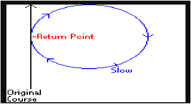
Williamson Turn
6. TThe Williamson turn is a maneuver used to bring a ship or boat under power back to a point it previously passed through, often for the purpose of recovering a man overboard.
The Williamson turn is most appropriate at night or in reduced visibility, or if the point can be allowed to go (or already has gone) out of sight, but is still relatively near. For other situations, an Anderson turn (quickest method) or a Scharnow turn might be more appropriate. The choice largely depends on prevailing wind and weather conditions.
- Put the rudder over full.
- If in response to a man overboard, put the rudder toward the person (e.g., if the person fell over the starboard side, put the rudder over starboard full).
- After deviating from the original course by about 60 degrees, shift the rudder full to the opposite side.
- When heading about 20 degrees short of the reciprocal, put the rudder amidships so that vessel turns onto the reciprocal course.
- Bring the vessel upwind of the person, stop the vessel in the water with the person alongside, well forward of the propellers
- If dealing with a man overboard, always bring the vessel upwind of the person. Stop the vessel in the water with the person well forward of the propellers.
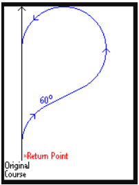
Scharnow Turn
The Scharnow turn is a maneuver used to bring a ship or boat back to a point it previously passed through, often for the purpose of recovering a man overboard. The Scharnow turn is most appropriate when the point to be reached is significantly further astern than the vessel's turning radius. For other situations, an Anderson turn or a Williamson turn might be more appropriate.
- Put the rudder over full.
- Put the rudder over hard. If in response to a man overboard, put the rudder toward the person (e.g., if the person fell over the starboard side, put the rudder over hard to starboard).
- After deviating from the original course by about 240 degrees, shift the rudder hard to the opposite side.
- When heading about 20 degrees short of the reciprocal course, put the rudder amidships so that vessel turns onto the reciprocal course.
- If dealing with a man overboard, always bring the vessel upwind of the person. Stop the vessel in the water with the person well forward of the propellers.
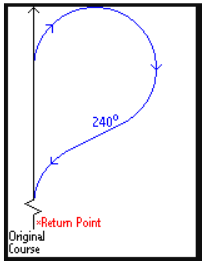
Chapter 5 — Medical Signal Code
(Use International Code of Signal Chap. 3)
1. Groups from the International Code of Signals may be used alone or in conjunction with signal groups from this annex. Whenever international groups are used alone in a flag-hoist, international procedure is to be used in answering.
2. Whenever military use is made of the International Code of Signals, groups will be preceded by CODE when transmitted by flag-hoist, or INTERCO by Morse, voice, or semaphore.
2.1. Whenever international signals are used alone, CODE or INTERCO followed by TACK shall be used as the first group to indicate that all groups following are taken from the International Code of Signals. When the signal consists of only one group, TACK may be omitted.
2.2. Whenever signals from this book are supplemented by a group from the International Code of Signals, CODE or INTERCO shall immediately precede the signal group to indicate that only that group is taken from the International Code of Signals.
2.3. For flag-hoist signaling, a call sign preceding CODE indicates Allied procedure will be used in answering, repeating, questioning, and canceling the display. For multiple signals, a call sign preceding CODE may be hoisted in a superior position and left flying during several succeeding hoists of international code groups. In either case, hauling down the call sign and CODE indicates the end of the message.
- Whenever international signals are used alone, CODE or INTERCO followed by TACK shall be used as the first group to indicate that all groups following are taken from the International Code of Signals. When the signal consists of only one group, TACK may be omitted.
- Whenever signals from this book are supplemented by a group from the International Code of Signals, CODE or INTERCO shall immediately precede the signal group to indicate that only that group is taken from the International Code of Signals.
- For flag-hoist signaling, a call sign preceding CODE indicates Allied procedure will be used in answering, repeating, questioning, and canceling the display. For multiple signals, a call sign preceding CODE may be hoisted in a superior position and left flying during several succeeding hoists of international code groups. In either case, hauling down the call sign and CODE indicates the end of the message.
Chapter 6 — Passing Honors
Honors are salutes rendered to individuals of merit, such as recipients of the Medal of Honor, to high-ranking individuals, to ships, and to nations. The type of honors rendered depends upon who or what is being saluted.
Passing honors are rendered by a ship to other ships and to boats having officials embarked. Side honors are rendered to officials or officers as they board and depart a Navy ship. Gun salutes are rendered to high-ranking individuals, to nations, and to celebrate national holidays.
PASSING HONORS. Passing honors are honors (other than gun salutes) rendered on occasions when ships, officials or officers pass in boats or gigs, or are passed (flag officers or above) close aboard. “Close aboard” means passing within 600 yards for ships and 400 yards for boats.
Passing honors between ships, consisting of sounding “Attention” and rendering the hand salute by all persons in view on deck and not in ranks, are exchanged between ships of the Navy and the Coast Guard passing close aboard. Signals for the actions required to be performed by personnel are as follows:
- One blast—Attention (to starboard)
- Two blasts—Attention (to port)
- One blast—Hand salute
- Two blasts—End salute
- Three blasts—Carry on
On the signal of “Attention,” all hands in view on deck (starboard or port as indicated by number of blasts) come to attention and face outboard. At the sound of one blast, all hands in view and not in ranks salute. (When personnel are in ranks, only the division officer and the division petty officer salute; all other persons stand at attention.)
At two blasts, persons saluting bring their hands back to their sides but remain at attention until three blasts are sounded. For boats passing honors, flag officers, unit commanders, or commanding officers in uniform embarked in boats are saluted by all persons on the quarterdeck.
Ships will be placed in a column formation (Form 1 figure below) and in the interval declared with station 1 the lead ship in the line. Subsequent stations in the line are directly astern station 1 and are numbered sequentially (stations 2, 3, 4, etc.).
The bearing between stations in the line is the same as the course of the column formation. The distance (d) between stations is the standard distance (D) promulgated in the tasking message. The Guide can be assigned to any station.
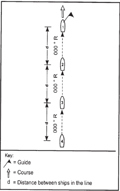
Annex A — Glossary of Terms, Acronyms, and Abbreviations
This annex provides a glossary of terms, with reference paragraphs in parentheses, and a list of acronyms and abbreviations used in this manual.
02. Glossary of Terms
Chain of Command. The succession of authority of commanders within a task organization.
Change of Operational Control (CHOP). The shift of responsibility for command and/or control from one commander to another.
Circular Formation. A formation in which ships are assigned stations around a central location.
Column Formation. A line formation in which ships are aligned bow to stern.
Column Open Order. A modification of a line formation in which ships are displaced on each side of the stern of the lead ship.
Command. The authority vested in an individual to direct, coordinate, and control forces.
Commander Task Element. The commander assigned command and control authority over forces assigned to a task element.
Commander Task Group. The commander assigned command and control authority over forces assigned to a task group.
Commander Task Unit. The commander assigned command and control authority over forces assigned to a task unit.
Control. The authority exercised by a commander over part of the activities of subordinates.
Coordination. The establishment of planned actions to achieve the best overall results.
Corpen. A line formation maneuver in which ships alter course so that the relative bearing to the guide is the same at the completion of the maneuver as it was at the start of the maneuver.
Designated Station. An area or point established in advance for assigning ships within a formation. Designated stations apply only to the exercise or operation for which they are developed.
Diamond Formation. A formation of ships that resembles a diamond. A diamond formation can be formed only from a column formation.
Direction. The process of planning, establishing priorities, formulating policies, and imposing decisions.
Distance. The distance between ships in a line.
Formation. The orderly grouping of ships for the purpose of safely and efficiently completing an exercise or operation objective.
Guide. The ship in a formation on which other ships take station.
INTERCO. A code word that indicates signals are from the International Code of Signals.
INTERROGATIVE. A signal modifier that denotes a question.
Interval. The distance between lines of ships in a multiple line formation.
Line Abreast Formation. A line formation in which ships are aligned beam to beam.
Line Formation. One of several basic formations in which ships are stationed along a line.
Line of Bearing Formation. A line formation in which ships are aligned along a designated bearing.
NEGAT. A signal modifier that denotes .cease or do not.
Operational Command and Control. The authority to assign ships as participants in an exercise or operation, to deploy ships to meet exercise or operation commitments, and to authorize ships to detach from an exercise or operation.
Position and Intended Movement (PIM). The general track along which a task group will proceed. A PIM consists of a position, time of position, course, speed, and time in hours for which the course and speed is in force.
PREP. A signal modifier that denotes. Prepare to..
Readiness. The ability of a command to carryout an assigned exercise or operation.
Sequence Number. A number assigned to a ship in a task group to facilitate close maneuvering and stationing.
Standard Position. One of a series of positions that is valid during all exercises or operations.
Station. The position within a formation assigned to a ship.
Tactical Command. The authority to assign ships to specific tasks within an exercise or operation.
Tactical Control. The authority to direct and control the movements or maneuvers of ships to accomplish an exercise or operation.
Task Element. A command and control grouping of forces subordinate to a task unit.
Task Group. The largest command and control grouping of forces involved in an exercise or operation.
Task Organization. The structure that delineates command and control responsibility of forces involved in an exercise or operation.
Task Unit. A command and control grouping of forces subordinate to a task group.
Turn. A formation maneuver in which all ships alter course simultaneously and maintain true bearing to the Guide.
03. List of Acronyms and Abbreviations
| Acronym | Meaning |
|---|---|
| CHOP | Change of Operational Command |
| CTE | Commander Task Element |
| CTG | Commander Task Group |
| CTU | Commander Task Unit |
| D | Standard Distance |
| d | Distance |
| DESIG | Designation |
| EMERG | Emergency |
| FORM | Formation |
| GMT | Greenwich Mean Time (Zone 0, Z) |
| I | Standard Interval |
| INT | Interrogative |
| INTERCO | Signals are from the International Code of Signals |
| kt | Knot(s) |
| MIO | Maritime International Operation |
| NEGAT | Cease or do not |
| nm | Nautical Mile(s) |
| OSC | On-Scene Commander |
| PIM | Position and Intended Movement |
| POL | Petroleum, Oil, and Lubricants |
| PREP | Prepare to |
| Center of the front of a Formation | |
| R | Relative |
| RAS | Replenishment at Sea |
| RP | Reference Point |
| STBD | Starboard |
| T | True or Time |
| TACK | Tack-line ( . ) |
| TE | Task Element |
| TG | Task Group |
| TT | Originator’s Position |
| TTW | Territorial Waters |
| TU | Task Unit |
| VERTREP | Vertical Replenishment |
| XX | Position upon which an evolution is based |
| yd | Yard(s) |
| YY | Addressee’s Position |
| ZZ | Formation Center |
| ° | Degree(s) |
